International boundaries
1.04 Namibia's borders3
Namibia gets its shape and area from a set of defined borders. How Namibia came to have those borders is a story stretching back almost 170 years, consisting of countless negotiations, multiple treaties, and many delimitation and geodetical commissions. Most of these involved the German, British and Portuguese governments during their scramble for colonial influence in Africa in the nineteenth century.
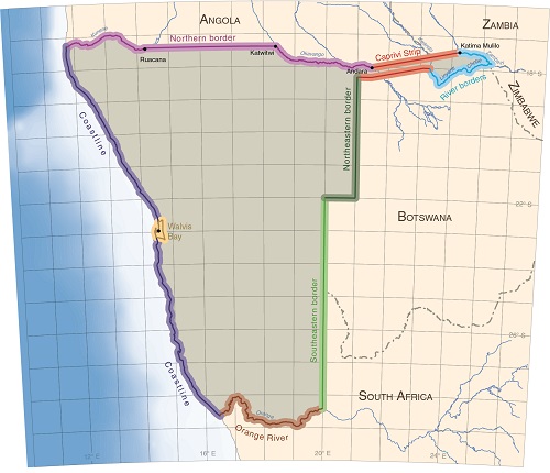
Northern border: It was in the German–Portuguese Treaty of December 1886 that this border was first defined as following the Kunene River to a point near Ruacana, and then due east to a point at Katwitwi, and then along the Okavango River to Andara. However, uncertainty and disagreement about the exact point near Ruacana led to the declaration in 1891 of a neutral zone 8 miles (12.9 kilometres) wide. A proper survey was completed in 1928 and the neutral zone then fell away.
Caprivi Strip: The idea of the Caprivi Strip was also first agreed in the Portuguese–German Treaty of December 1886 when the northern boundary was agreed to be a straight line from Andara to the rapids at Katima Mulilo. However, the general area in and around today's Zambezi Region was under British influence at that time, and it was during the negotiations leading up to the Heligoland–Zanzibar Treaty of 1890 that the Caprivi Strip was first declared as being part of German South West Africa, and was named after Count Leo von Caprivi, Germany's chancellor at that time. This treaty also fixed the width of the Caprivi Strip as 20 miles (32.2 kilometres). The survey and marking out of the northern boundary was only completed in 1931. The British and German governments interpreted the southern boundary's position differently, especially where it was difficult to determine distances of 20 miles south of the Okavango River, and it was only in 1930 that the position of the southern border was fixed. About half of the Caprivi Strip lies in present-day Kavango East Region; the other half is in Zambezi Region.
Kwando, Zambezi, Chobe and Linyanti river borders: These borders were defined as the centre lines of the deepest channels of the four rivers. However, the depths of the channels change as the rivers meander, making it hard to determine which channels are deepest. Consequently, the sovereignty of certain islands in the rivers has been disputed.
Northeastern border: This border was only demarcated with beacons in 1964. From the southwestern corner of the Caprivi Strip it runs due south along 21 degrees east to 22 degrees south, then due west to 20 degrees east.
Southeastern border: This border follows the 20 degree meridian from 22 degrees south to the Orange River. This border was first agreed in March 1885, and then ratified by Britain and Germany in their 1890 treaty. Beacons were placed to demarcate the border during a geodetical survey between 1899 and 1903.
Orange River: The Orange River was confirmed as a border in the German–British Treaty of 1890, from the mouth of the river to a point where the river meets 20 degrees east. Contrary to usual practice where borders run along the midline of rivers, it was agreed that this border would follow the highest flood level on the northern bank, thus keeping all the river's waters in South Africa. South Africa and Namibia agreed in 1991 to move the border to the centre of the river, but the governments have yet to implement this agreement.5
Coastline: The coastal border stretches approximately 1,570 kilometres from the mouth of the Orange River northwards to the mouth of the Kunene River. This was agreed in the German–Portuguese Treaty of December 1886, thus altering an earlier agreement between the British and German governments in March 1885 that fixed the northernmost point of Namibia's coastline at a latitude of 17.85 degrees south, a point approximately 66 kilometres south of the Kunene River mouth.
The Walvis Bay enclave was proclaimed British territory in 1876, and then as part of the Cape Colony in 1884. It remained part of South Africa after Namibia's independence, but South Africa ceded Walvis Bay and the offshore islands to Namibia in a treaty in 1994.
Photo: John Mendelsohn
Beacon 24, about 230 kilometres due east of Ruacana Falls is one of 47 beacons erected in 1927 and 1928 following an agreement between Portugal and South Africa. The agreement signed on 22 June 1926 read in part: … When this boundary follows a parallel of latitude or other straight line, the demarcation shall be made without any extensive deviation from that parallel or line. ln demarcating the boundary line from the Kunene to the Okavango (Cubango) River, the latitude of boundary marks shall be corrected by means of astronomical observations at distances of not more than fifty kilometres apart … permanent beacons shall be erected along the said boundary line at distances not exceeding 10 kilometres apart … The whole of the boundary line shall be cleared and kept free of bush and trees.4

Photo: H Baumeler
Namibia's eastern border with Botswana goes up and down over hundreds of dunes and hummocks of red Kalahari sand.
1.05 Namibia's marine territory and exclusive economic zone6
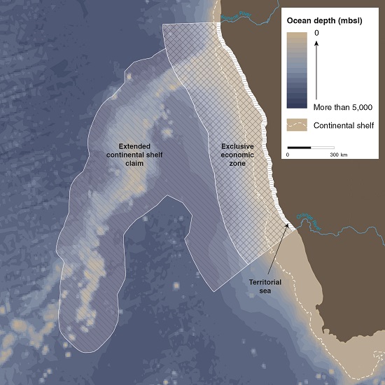
Namibia is separated from its neighbours by land borders, but sovereignty at sea is defined by distance. Namibia's territory extends 12 nautical miles (22.2 kilometres) out to sea from the average low-tide line. An exclusive economic zone was established in 1990, which extends 200 nautical miles (370.4 kilometres) offshore, giving Namibia sole rights to the exploration and exploitation of marine resources within this area of the Atlantic Ocean. In 2009, Namibia submitted a claim to the United Nations Commission on the Limits of the Continental Shelf (CLCS) to claim its rights over an extended area of continental shelf.

Photo: J Paterson

Photo: J Mendelsohn
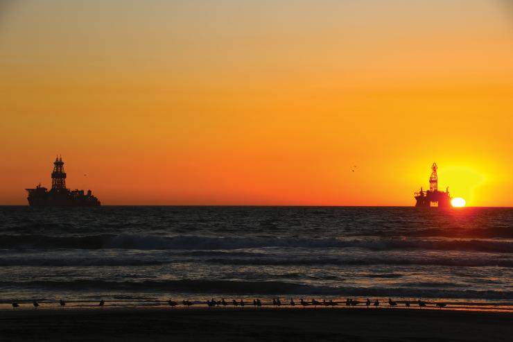
Namibia seeks to protect its rights to the country's offshore waters and the fish and other marine life they support, as well as the rights to mineral and petroleum resources in this area of the Atlantic Ocean.


