

Some essentials
Certain fundamental features and processes have wide-ranging effects. Without them, Namibia would look and function quite differently. These basic features are: the country's physical relief; the Benguela Current and the associated southerly winds; the aridity; the easterly winds; fire; the rivers; the soils; and the impacts of people. The shaping of the country by these features and processes often happens in interconnected ways, many of which are discussed in the chapters and pages ahead.
Physical essence of Namibia
Namibia comprises three main landscapes or land shapes: the coastal margin, a slowly rising plain inland of the shoreline; a central ridge of hills and mountains that runs north–south; and an eastern plateau, a sandy flat region that stretches to Namibia's eastern extremities. Namibia’s only perennial rivers flow along its borders: there are two westward-flowing rivers along the northern and southern border and three that flow eastwards in Namibia's northeast.
In separating the Atlantic Ocean from much of the hinterland, the coastal margin has elements that come from the sea (such as sand dunes and saline soils) and elements from inland (ephemeral rivers and their linear oases of riparian vegetation and alluvial sediments). Erosion has created and expanded the plain's even surface over the past 132 million years, when the coastline was formed following Namibia's split from South America.
The central ridge is mostly hilly and rocky with shallow soils, and is deeply dissected by rivers that are now ephemeral. The catchments and watersheds of these rivers are well defined. The waters of these rivers are erosive and fast moving when they occasionally flow from the highlands down to the coastal margin, where they lose energy and slow down on its gentler slope. Some surface water on the central ridge is held back by dams, of which almost 8,000 have been constructed in this hilly landscape. Groundwater moves along fractures between and within blocks of rock, from which about 2,500 small springs bring water back to the surface. Most of Namibia's mines are in the central ridge and, to a lesser degree, in the coastal margin.
The eastern plateau of Namibia is very different to the rest of the country. Deep sands blown in mostly from the east and north blanket the eastern plateau. Many watercourses here have not flowed any distance in living memory because almost all rainwater seeps rapidly away into this sandy and very flat landscape. When the rivers do have water, flows are sluggish and soon disappear into their sandy beds. The catchments of these rivers are vaguely defined and few dams have been built on the eastern plateau, but there are about 25,000 pans. Groundwater percolates between grains of sand into porous aquifers.
The Cuvelai in the far north of the eastern plateau, is somewhat different. Here a network of drainage channels continues to periodically carry water, leaving sediments behind after the water evaporates. It is these salty sediments that form the foundation of Etosha and the many smaller saltpans nearby.

Benguela Current and southerly winds
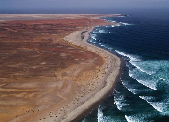
Photo: P van Schalkwyk
The coastal margin is arid for reasons of its location being in the west, below the escarpment, and adjacent to the cold waters of the Benguela Current. The cold Benguela Current and its associated southerly winds drive upwelling processes that bring nutrients from the ocean depths to the surface; these nutrients nourish the tiny plants and animals that sustain the rich offshore fish stocks, which support the development and economy of coastal towns. These rich waters and the wealth of fish also sustain great numbers of marine mammals, and seabirds that produce guano while nesting and roosting on Namibia's islands; a resource that was mined in the second half of the nineteenth century.9 Guano and whale industries flourished at one time in Namibia and seals and fish are still harvested. More recently there has been a controversial proposal to mine phosphates from the ocean floor, and diamonds have been mined there for some decades. The winds have also whipped the Atlantic into a fury causing the wreckage of hundreds of ships, giving Namibia's northern coast its name, Skeleton Coast.
The combination of humid maritime air and the cool ocean brings fog to Namibia's coast, and this is the most dependable source of fresh water for many plants and animals found here.
The Benguela and southerly winds bring energy to the coast, but the energy ultimately comes from two bigger engines. First is the power of the Coriolis force in driving water and air anticlockwise in the southern hemisphere, dragging cold water northwards to wash Namibia's shores. The second is the South Atlantic Anticyclone, a giant turbine that drives air and pushes water northwards, towards and then along the Namibian coast. Economists and environmentalists keen on measuring the value of ecosystem services would be hard placed to find greater powerhouses of Namibia's economy than the South Atlantic Anticyclone and Coriolis force. To these dynamos, Namibia owes its riches of diamonds and marine resources, and the formation of the tourist-attracting Namib Sand Sea.
Aridity
Namibia is generally arid for two major reasons: limited rainfall and high rates of evapotranspiration. Low humidity adds to the dry climate. Northeastern Namibia receives the most rain (more than 600 millimetres a year, on average) and the earliest rainfalls of the season. This is because this area is closest to the source of moist tropical air from which most of Namibia's rain is derived and which steadily diminishes to the south and west. The direct and indirect consequences of aridity are many. For example, soil moisture and soil fertility are low, and vegetation is sparse and often has to endure long periods of drought in various forms of dormancy. Animals cope with aridity by being opportunistic and moving over large areas, having low metabolic rates and/or being dormant for much of the time. The arid climate also dictates the land's suitability for farming and, as a result, large areas of the country are used for pastoral livestock keeping and production, rather than for crop farming. Namibia's aridity also gives it the distinction of having some of the clearest skies and, consequently, perfect opportunities for stargazing.
Easterly winds
Easterly winds have multiple effects on Namibia. They are most common during the dry winter months when the Botswana Anticyclone lies inland. As air descends over the Escarpment, it dries and heats up, bringing the highest temperatures of the year to the coast in the winter months! These winds can blow enormous quantities of sand and fine sediments hundreds of kilometres across the country and into the Atlantic Ocean. Elsewhere, these easterlies mix aeolian and fluvial sediments to create locally fertile soils on which people settle to grow crops. During more arid eras, easterly winds scoured sands from the dry riverbeds of the Okavango and Kwando rivers and the Omatako Omuramba and moulded them into linear dunes west of these rivers. Etosha and other saline pans were formed by the scouring action of easterly winds, and lunette dunes have been formed where easterly winds dumped fine sediments on the western margins of Etosha Pan.
Fire
Easterly winds cause leaf litter to collect on the western, leeward side of the trunks of large trees in northeastern Namibia. When bushfires sweep across the landscape the dry leaves burn fiercely, in the process creating hollowed scars in the trees' trunks. The hollows enlarge after each fire, which then progressively hold more dry leaves. The fires become hotter and hotter until the trees die, contributing to the conversion of large areas of tall woodland into shrubland. Other large areas of Namibia are covered by dense bush or shrubs, but this bush encroachment is mainly due to a lack of fires on farms managed for commercial livestock production. Fire thus has substantial effects on woody vegetation.
Rivers
Namibia has only five perennial rivers, but hundreds of ephemeral rivers and streams. The perennial rivers delineate or cross Namibia's northern and southern borders. Two of them are aggressive: the west-flowing Orange and Kunene rivers, at times delivering particularly powerful flows during the rainy season because they drop steeply to sea level from elevations of 1,600 metres and more. Both contribute much to Namibia's welfare. It is the Orange that sorted and exported the best diamonds from Lesotho, South Africa and perhaps Botswana to Namibia, and it is the Kunene that supplies up to 45 per cent of the electricity produced in Namibia, and water to about 35 per cent of its population.
Both the Kunene and Orange can be very muddy, carrying huge sediment loads eroded off their upland catchments. By contrast, waters of the Okavango, Kwando and Zambezi rivers are clear and placid because most of their catchments of deep, infertile sand are only hundreds of metres higher than their watercourses at the northern borders of Namibia.
Namibia's ephemeral rivers are dry most of the time and seem to offer the country little. Yet, all of Namibia's impoundments or storage dams are on these rivers. Their rich belts of riverine vegetation are linear oases that support many animals, and both man and beast are supplied with water by natural springs, hand-dug wells and deeper aquifers along their courses.
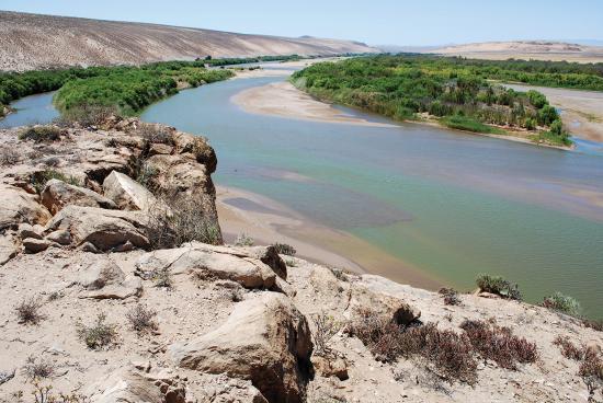
Photo: J Pallett
The Orange River along Namibia's southern border is placid for much of the time. However, following heavy rain in southern Africa’s interior, the Orange carries raging flows of water and mud down to the Atlantic Ocean.
Soils
Soils in Namibia are largely a product of its arid and semi-arid environment. Most are shallow, saline or extremely alkaline soils, or inert windblown sands – all qualities that limit soil fertility. These features together with high rates of evapotranspiration and low rainfall limit the biomass of plants and animals, agricultural production, the quality of rural livelihoods, population size and national wealth. Minerals of potential value are covered over by the deep sands that blanket more than a third of the country, with the result that almost all of Namibia's mines are on exposed areas of the Coastal Plain or the central ridge of hills.
Namibia's people and the economy
People lived as hunters and gatherers in Namibia for several hundred thousand years, if not more. Most household economies changed with the introduction of farming by immigrant agropastoralists about 1,000 or more years ago. At that time, farming largely supported subsistence livelihoods, with farm produce being used for domestic consumption and livestock as capital savings. Another major change began with the start of the colonial era about 140 years ago and has since accelerated as households became increasingly reliant on monetary income. Increasing demands for financial security, combined with the limited productivity of rural soils and the weather, have had many effects on Namibia's people and land. The most obvious has been the movement of people from rural to urban areas in recent times, attracted there because cash incomes are more readily available in towns and cities. Consequently, in the last decade urban centres have grown rapidly, at about 4 per cent per year on average, while rural populations have become smaller.
High demands for housing, and the absence of tenured land on which migrants to cities can settle, has led to the substantial growth of informal shack housing. The informal economy in towns has also expanded rapidly, providing more sources of income than formal jobs. Substantial sums of money move from urban to rural areas as remittances, resulting in an increase in cash incomes from non-farming sources in rural areas. As a result, rural households are becoming wealthier and less dependent on local natural resources, retail trade in rural areas is expanding and rural homes are increasingly built from materials purchased with cash, rather than with labour using locally harvested plant materials.
While the distribution of Namibians and their livelihoods has been changing rapidly, tenure arrangements have hardly changed from those established when most Namibians had rural homes and were assumed to subsist on local harvests. Thus, the supply of land for housing in urban areas has been far lower than demand, and the great majority of residents in communal areas lack tenured rights of ownership that would facilitate measures to develop financial security. Commonage is largely used to keep livestock, which in most areas are kept as security or savings. The division of communal land into large private farms that began in the 1880s continues.
These are among the most important drivers that make Namibia so varied, rich and fascinating. The pages and chapters ahead will illustrate many other linkages and processes that have built, and continue to build, the country.

Photo: J Pallett
Gabis is one of several small, little-known villages in southern Namibia. It is situated in ||Kharas Region along the ephemeral, but well-vegetated, Hom River a few hundred metres downstream of the Dreihuk Dam; it falls within the ||Gamaseb Conservancy. Some residents farm goats or chickens and/or tend small gardens, and most households generate some income through piecework, such as sheep-shearing and fencing, on commercial farms. Making a living in this remote, extremely arid and often hot area is not easy.