Second period, Gondwana's formation: 900–550 million years ago
The second historical period started when Rodinia began to break apart around 900 million years ago. That split Namibia and its neighbours in Rodinia into three landmasses, namely the Kalahari Craton to the east, the Congo Craton to the west, and the Rio de la Plata Craton to their south. Two deep oceans formed as the craton landmasses drifted apart. The Adamastor Ocean extended along a north–south axis from present-day Kunene in the north to the Orange River in the south following a similar trend to Namibia’s current Atlantic coastline, while the Khomas Ocean cut a swathe through present-day central Namibia.
Great volumes of sediments were eroded off the landmasses and deposited in the oceans. At the same time, hot semi-fluid magma rose from the earth's upper mantle, becoming lava on the surface where it cooled and solidified into volcanic rock. Together with the sediments, successions of interbedded sedimentary and volcanic rocks were formed, which are today part of the Nosib Group in the Damara Orogen. Many saline lakes also formed within these large basins, much like the present-day lakes of the East African Rift Valley.
The denser oceanic crust between the three continental landmasses began to sink about 700 million years ago. This led to the convergence of the three landmasses and the closure of the oceans. By about 550 million years ago, the landmasses of the southern hemisphere had been consolidated into the supercontinent Gondwana. During the process of convergence, oceanic sedimentary rocks in the Khomas and Adamastor oceans were pushed up and metamorphosed into the extensive mountain belts of the Damara Orogen in central Namibia, and the Gariep Orogen and Kaoko Belt in southern and northern Namibia, respectively.
The compressive forces were enormous, heating, pressurising and melting rock, which then rose because it was lighter and thus more buoyant than the surrounding rock. The molten rock formed the intrusions of Damara Granites, such as the extensive Donkerhoek and Omangambo granites, the uranium-bearing Rössing Alaskite, and tourmaline-bearing pegmatites in central Namibia.
As colliding landmasses are pushed upwards to create mountain ranges, large basins form behind them as the colossal weight of the mountains causes the surrounding land to subside. Both the Nama Basin in the south and the Owambo Basin in the north of Namibia were thus formed during the Damara, Gariep and Kaoko mountain-building events. The Nama and Owambo basins were eventually filled with debris eroded off the newly built mountain belts, the debris respectively forming the Nama Group (figure 2.18) in southern Namibia, and the Mulden Group, most of which lies beneath the Owambo Basin and its Cuvelai drainage system.
Earth, 900 million years ago
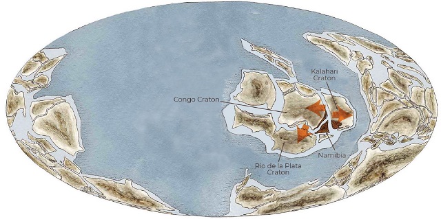
Rodinia had not yet broken up. The three cratons that formed Rodinia – Congo, Kalahari and Rio de la Plata – then began to drift away from each other and, as the rifts between them widened, the Khomas and Adamastor oceans came into being.
2.18 Gondwana's formation, 900–550 million years ago
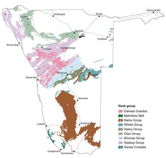
Most geological formations belonging to this period began as sediments in the Damara and Adamastor oceans before they were later pushed up to form the extensive mountain belts of the Damara Orogen in central Namibia and the Gariep Orogen in southern Namibia. The rock groups of these two formations are mapped in the various units shown in this map. The processes that led to the building of the mountain belts also led to the formation of Gondwana, the new supercontinent.

Photo: J Irish
The calm, shallow waters near the edges of the landmasses were probably warm, sunlit and full of simple forms of life such as algae and stromatolite-forming cyanobacteria. Photosynthesis enabled plant life to fix carbon from the atmosphere and bind it to calcium to form calcium carbonate,18 which eventually became the limestones and dolostones of the present-day Otavi Group in the Otavi–Grootfontein–Tsumeb hills that extend westwards to Outjo and northwards towards the Ruacana area. This photo shows the Uhlenhorsthöhle, a cave in the Otavi area, which is one of many dissolved in the limestones by groundwater. Other limestone belts lie between the Gamsberg and Steinhausen east of Okahandja and in formations of the Nama Group.
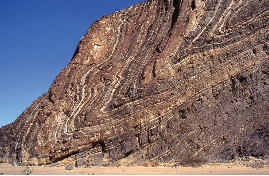
Photo: J Kaufman
These turbidites were formed predominantly from inorganic sediments that slid down the slope of the continental shelf into deeper water. The turbidites in the depths of the Khomas and Adamastor oceans were then metamorphosed to form the basis of much of the rock of the Khomas and Hakos groups found in central Namibia today (figure 2.18). Many of the rocks in Namibia are folded, but the most spectacular folds are seen in the turbidites along the Ugab River, west and north of the Brandberg, as illustrated here.
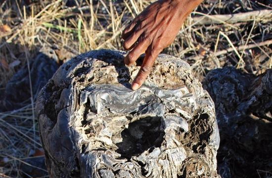
Photo: J Mendelsohn
The period of erosion and sedimentation in the Adamastor and Khomas oceans was interrupted twice by episodes of global glaciation. These 'Snowball Earth' events occurred about 720 million and 635 million years ago. In places, the glaciers left their marks as striated and polished rock surfaces, as seen on this block of dolomite and fossil stromatolites, or in thick deposits of glacial debris.

Photo: J Mendelsohn
Metamorphism of the basalts of the mid-oceanic ridge in the Khomas Ocean produced the copper-rich Matchless Belt of amphibolite rock, which runs for about 350 kilometres from the Kuiseb River near Gobabeb to Windhoek and beyond. Similar volcanic rocks that extruded at the Adamastor mid-oceanic ridge are now part of the Gariep Complex of southwestern Namibia. These green rocks of the Matchless Belt are easy to see below the water reservoirs on the hill next to Windhoek's fire station.

Photo: JB Dodane
As mountains of the Damara Orogen were eroded in the Hakos area west of Rehoboth, tremendous pressure on underlying rocks was released. Geologists conclude that the underlying compressed rocks rebounded, tilting and lifting, and then slid southwestwards for almost 80 kilometres over the younger Nama Group to form the Naukluft Mountains.
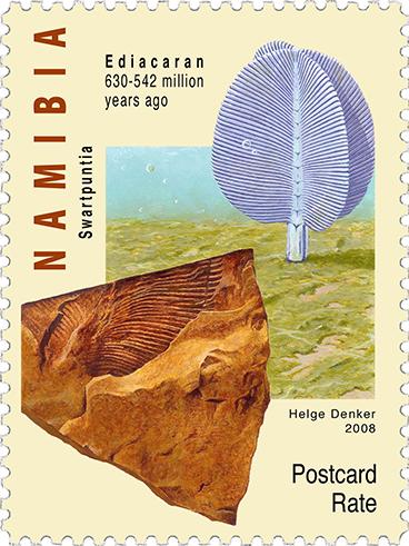
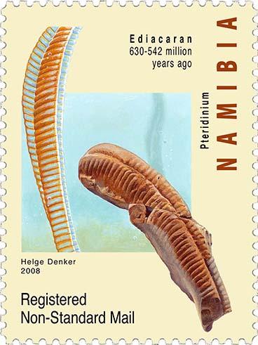
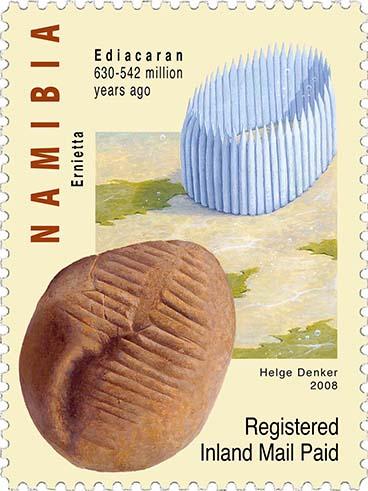

Art: Helge Denker; Copyright: NamPost
The shales, sandstones, limestones and conglomerates of the Nama Group contain an extensive record of fossil organisms that made up Precambrian life (older than 540 million years), commemorated here in a 2008 issue of Namibian stamps. The organisms represented in the fossils were soft-bodied and generally only preserved as impressions making them difficult to study and understand. They lived during the Ediacaran Period, 635–541 million years ago. What are believed to be primitive sponges have been described from the Nama Basin, as well as small shelly fossils, which were the first animals with a skeleton.
Earth, 550 million years ago
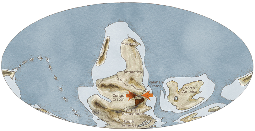
The formation of the supercontinent Gondwana occurred when the Rio de la Plata, Congo and Kalahari cratons collided. This process also closed the Khomas and Adamastor oceans.
