

Conservation
8.09 Conservation areas, 202114

Government has set aside 17 per cent of Namibia's land for conservation as state-protected parks and reserves. In addition to this, large areas of communal and freehold land are also used for conservation, and to generate income for their residents and owners. As popular attractions for tourists, national parks or state-protected areas contribute significantly to employment and the national economy, as do the private lodges along the parks' borders. Many areas that remain out of bounds within stateprotected areas could be opened for the benefit of both Namibian and foreign tourists
Land falling under conservation management falls into the following categories:
- National parks, which are administered by the Ministry of Environment, Forestry and Tourism, are used for wildlife conservation, research and tourism only. There are exceptions, such as in the Namib-Naukluft and Bwabwata national parks where people living there have the right to use designated areas of the parks for certain uses.
- Etendeka, Hobatere and Klein Aus Vista tourism concessions are on state-owned land, but are managed for wildlife conservation and tourism by their respective concession holders. Private-sector tour operators and conservancies may also be granted rights to earn income from tourism in certain areas within national parks. Only the largest of these concessions are shown on the map.
- Communal conservancies are institutions on communal lands that are governed by resident conservancy members. These institutions have rights over certain natural resources, including wildlife, and over tourism within the conservancy, but they are subject to control by the Ministry of Environment, Forestry and Tourism. Conservancies have legally defined boundaries, but they are not fenced.
- Community forests are also governed by resident members who have rights over all types of natural resources, including timber, grasses, wild fruits and animals, and over tourism. Community forests often fall within communal conservancies but are managed separately.
In addition to local designations, some areas in Namibia are internationally recognised for their conservation value. The Namib Sand Sea and Twyfelfontein are declared World Heritage sites. Ramsar sites are wetlands of international importance under the Ramsar Convention. Those declared in Namibia are the Orange River mouth, Sandwich Harbour, Walvis Bay, the Cuvelai (including Etosha Pan and the Omadhiya lakes) and the Okavango River in Bwabwata National Park. As well as the Ramsar sites, which are all important for birdlife, several coastal sites between the Orange and Kunene rivers are vital feeding grounds and stopovers for migratory shorebirds.
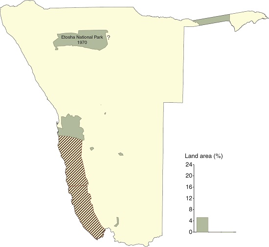
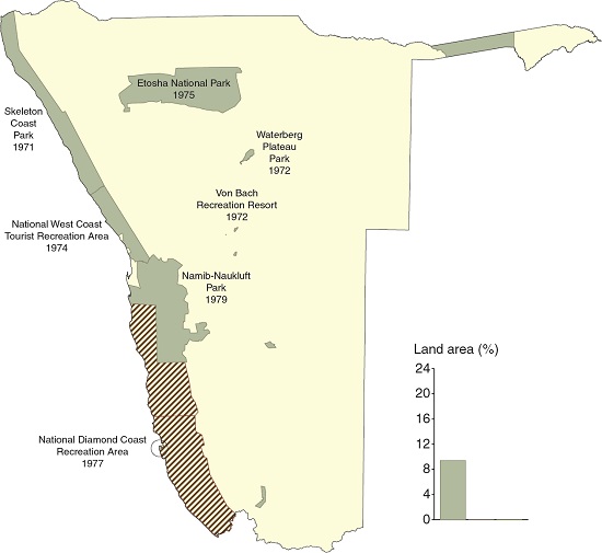
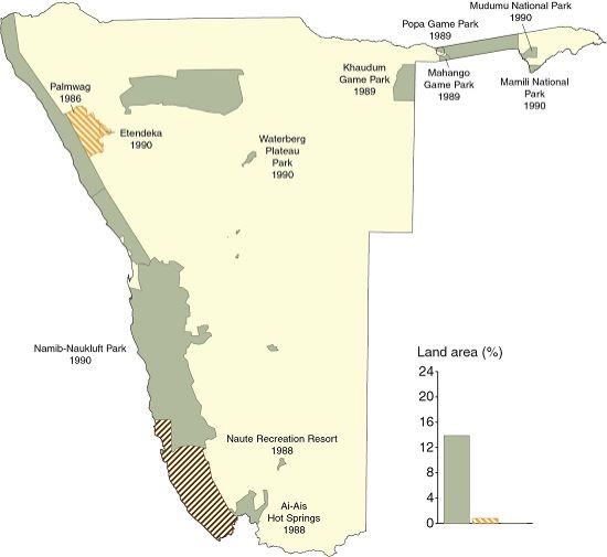
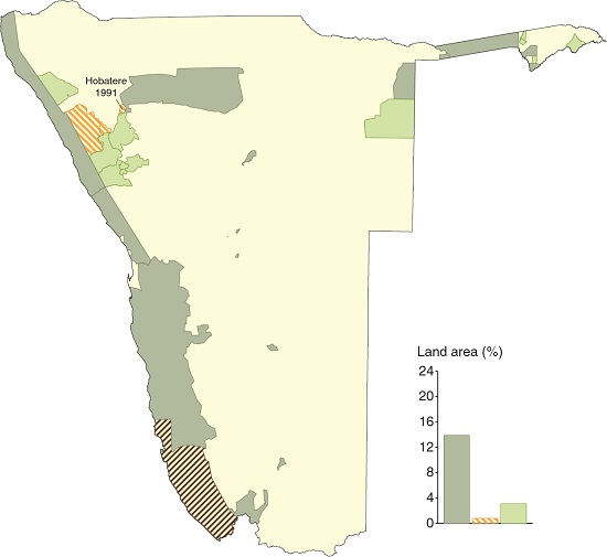
8.10 Growth of conservation areas, 1939–202015
1939

1969

1970
1980
1990
2000
2010

2020


The designation of protected areas in Namibia dates back more than a century to when the first reserves were established in 1907. Then known as Game Reserves 1, 2 and 3, their purpose was rather different from the roles that conservation areas serve today; their primary function then was to limit the movements of indigenous people and to exclude them from the wildlife resources in the three reserves.
Palmwag, Etendeka and Hobatere tourism concessions were established in the 1980s to offer safe refuges for local wildlife when wildlife was rapidly being decimated in northwestern Namibia.
The first communal conservancies were established in 1998 to enable residents on communal land to manage, utilise and benefit from wildlife and tourism in the same way as freehold farmers. By 2021 there were 86 formally gazetted conservancies spread throughout Namibia's communal land. Terrestrial state-protected areas then covered 16.9 per cent of Namibia, the three tourism concessions outside protected areas covered 0.8 per cent and communal conservancies covered 20.2 per cent. Although many of the community forests overlap the communal conservancies they add an additional 1.7 per cent.

Photo: L Polik
Game Reserve 2 was the precursor to Namibia's flagship protected area, Etosha National Park; it included all of northern present-day Kunene Region between the Hoarusib and Kunene rivers and a larger area around Etosha Pan, covering almost 80,000 square kilometres. Following World War I, Game Reserve 2 underwent several major boundary changes until the current boundaries of Etosha National Park were proclaimed in 1975. Game Reserve 1 was situated somewhere northeast of Grootfontein and was in existence from 1907 to 1958.
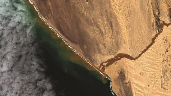
Photo: Sentinel
Protection of the northern section of the Namib from Walvis Bay to the Kunene River began with the designation of the Skeleton Coast Park in 1973. In December 2010, Dorob National Park and the Namibian Islands' Marine Protected Area were proclaimed. With the Sperrgebiet (below), the entire coastal zone from the Orange River to the Kunene River now falls within the state-protected conservation network. This image shows the Hoarusib River in a rare flood, when it reached the Atlantic coast on 28 March 2021. [19.06° S, 12.64° E]

Photo: C Begley
The Waterberg Plateau Park, shown here, was established in 1972. Prior to that, 1968 and 1969 saw the establishment of several other protected areas: Ai-Ais Hot Springs, Cape Cross Seal Reserve, Caprivi Game Park, Daan Viljoen Game Park, Gross Barmen Hot Springs, Hardap Recreation Resort, and the Namib Desert Park and Naukluft Mountain Zebra Park (the precursors to the Namib-Naukluft Park). Ai-Ais Hot Springs, in the far south, initially only covered the limits of the Fish River Canyon, but grew in 1988 and 2002 as neighbouring farmland was acquired and incorporated. In Zambezi Region (formerly Caprivi), the Caprivi Game Park formed a protective zone for animal movements between the Okavango and Kwando rivers and later in 1989 and 1990 Mahango Game Reserve, Popa Game Park, Mudumu National Park and Mamili (now Nkasa Rupara) National Park were added to the list of parks in northeastern Namibia. These parks in the northeast have become part of the Kavango–Zambezi (KAZA) Transfrontier Conservation Area (figure 8.13).

Photo: H Baumeler

Photo: JB Dodane
Höchster Mountain ('Highest Mountain'), in the foreground of photo (top), lies west of the Klinghardt Mountains in the Tsau ǁKhaeb (Sperrgebiet) National Park. The history of this park, and others, in southern Namibia is strongly linked to the two diamond areas that were proclaimed in 1939, some thirty years after the first diamond in Namibia was found in 1908. Access to these exclusive mining areas has been tightly controlled. In 1990, the Namib-Naukluft Park entirely replaced Diamond Area 2. It also included a small portion of Diamond Area 1, the rest of which was known as the Sperrgebiet, the 'prohibited area'. The remaining portion of Diamond Area 1, which covered an area of around 21,600 square kilometres, remained under the control of diamond-mining companies that evolved into Namdeb Diamond Corporation. Much of Diamond Area 1 was not affected by mining and has remained unscarred for almost a century. The area is also recognised as one of world's 34 biodiversity hotspots and was proclaimed in 2008 as the Sperrgebiet National Park. Entry to the park is still restricted.
8.11 Connections between conservation areas within Namibia16


The designation of lands adjacent to national parks has created large, contiguous areas under conservation management. In the northwest, conservancies and tourism concessions now adjoin the entire eastern boundary of the Skeleton Coast Park and form a broad corridor to Etosha National Park. This is vital in Namibia's arid environment in which many animals must cover large areas to find adequate forage and water. Conservancies in northeastern Namibia also help form corridors for game to migrate between conservation areas within Namibia and beyond its borders. Seventy-seven per cent of conservation areas (parks, conservancies, concessions, community forests) are interconnected in Namibia.
8.12 Mudumu Conservation Complex17

Complexes are mixed conservation areas under joint management and comprising national parks, communal conservancies and community forests. Management is led by the Ministry of Environment, Forestry and Tourism to improve the management of resources and activities at a landscape level. The Mudumu Conservation Complex encompasses an area around and including the eastern core wildlife area of Bwabwata National Park, seven conservancies, three community forests, and Mudumu and Nkasa Rupara national parks.
8.13 Transfrontier conservation areas18

Conservation linkages with neighbouring countries exist between the Skeleton Coast Park and Angola's Iona National Park, between |Ai-|Ais and South Africa's Richtersveld, and through the Kavango–Zambezi Transfrontier Conservation Area (KAZA) that links Angola, Botswana, Zambia and Zimbabwe with Namibia's Zambezi Region at its geographical heart. National and international linkages between state and community conservation areas facilitate wildlife movements, and the coordination of conservation and tourism activities.