Shipwrecks10
Combinations of thick fog, strong winds, heavy swells and shifting sands make the Namibian coastline hazardous for ships. Just how risky is illustrated by the great number of shipwrecks along our coast. Many of the wrecks are clustered in areas more hazardous than others, or in places where ships often congregated. For example, the 45 wrecks known around Ichaboe Island date from the mid-1840s when several hundred ships at any time were loading bird guano – the 'white gold' that was so highly valued. Many other ships came to harvest whales and fish along the Namibian coast.
Nowadays, ships are more robust, navigation systems and information are improved, and merchant vessels normally remain far from the coast. Most wrecks in recent decades are of fishing vessels or ships under tow that break free in bad weather. Tragedy and bravery surrounded each wreck, as in the circumstances told of the Dunedin Star. This cargo ship hit a submerged object in November 1942 near Cape Fria. All 21 passengers and 42 of the 85 crew reached shore; the rest of the crew remained on board. Two overland expeditions, four ships and a Ventura bomber were then sent to rescue them. The 43 crew members still aboard the Dunedin Star were saved by the ships. The Ventura landed on the beach to rescue the others, but it got stuck in the sand. Thirteen long days after the grounding of the Dunedin Star the survivors were eventually evacuated overland using vehicles. A team sent to free the stuck Ventura got the aircraft airborne, but an engine soon seized causing the plane to crash in the surf. Only two lives were lost in this whole sequence of events.

Photo: NamDeb

Photo: NamDeb

Photo: NamDeb
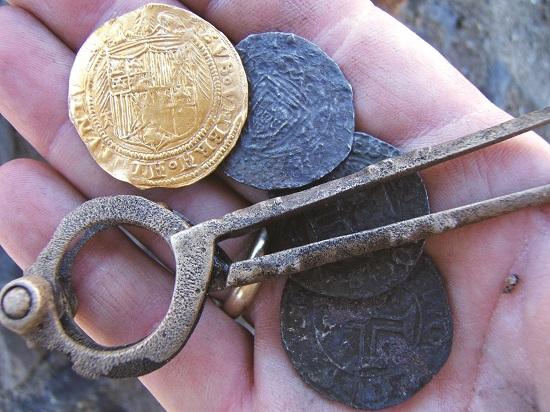
The wreck of the Bom Jesus was found north of Oranjemund in April 2008. The trading vessel had sunk in about 1533 en route from Portugal to India.11 The volume and variety of cargo recovered by archaeologists was remarkable: swords, guns and cannons; elephant tusks; 1,845 copper ingots; gold, silver and copper coins and dividers used for navigation; lead and tin ingots; astrolabes (for navigation); pewter plates, cups and jugs; and a variety of personal effects. The great number of ingots were probably intended for trade once the ship reached India. Between 1525 and 1600 twenty-one Portuguese ships were lost along the African coast on their way to the East, but only the Bom Jesus was known to have disappeared off Namibia.

Photo: S Rankl
The wreck of the 2,272-tonne Eduard Bohlen near Conception Bay now lies about 470 metres inland of the shoreline which has gradually shifted west by that distance since the ship ran aground in September 1909. In 2004 the wreck was only 390 metres from the shore. Brown hyaenas sometimes shelter in the wreck.
9.04 Shipwreck sites off the Namibian coast

About 300 ships are known to have sunk off the Namibian coast, while there is evidence that at least another 200 ships might also have been lost in these waters. This map shows the known locations of some wrecks. Many others were simply reported as having gone down somewhere off the coast. Each symbol on the map represents the location of a wreck.

Photo: J Mendelsohn
Wrecked in 1945, the Otavi is more intact than most Namibian shipwrecks because Dolphin Head in Spencer Bay protects the grounded vessel from the southerly winds and ocean swell.

Photo: JB Dodane
The Zeila ran aground south of Henties Bay on 25 August 2008. The fishing trawler had been sold as scrap metal and was under tow from Walvis Bay when it broke free and was wrecked.

Photo: JB Dodane
The bulk cargo carrier Frotamerica broke free of its tow and moorings and ran aground about 30 kilometres north of Lüderitz on 25 February 2013. Pollution from the 35,000-tonne vessel posed a risk to nearby marine life and seabirds on Ichaboe Island.

