

Why is Namibia so dry?
The flow of air around the planet – together with the oceans and their currents – determines how thermal energy and moisture are redistributed around Earth. Although influenced by various factors from one year to the next, these large-scale air movements are consistent in structure and are important factors in determining the climate at any location in the world. This is especially true for Namibia which straddles the Tropic of Capricorn and is bounded by the Atlantic Ocean with its powerful Benguela Current. Namibia's arid nature results from the persistent presence of dry air for most of the year and high rates of evaporation. Moist, warm air that can fall as rain reaches Namibia infrequently. This aridity is the product of the three major circulation systems discussed below.
Atmospheric circulation
Namibia's geographical position spans a zone roughly between 17 and 29 degrees south of the equator, along the southwestern coast of Africa. This places Namibia in an area where it is exposed to air movements in three major circulation systems or belts:
- The Intertropical Convergence Zone – or ITCZ as it is often referred to – near the equator is where the air masses from the northern and southern hemisphere come together. Air in the Intertropical Convergence Zone is moist and warm and it spirals upwards creating a belt of low pressure. As it rises, the air cools and the moisture condenses forming the great band of cloud clearly visible in the images in figure 3.01. This zone shifts seasonally, southwards towards Namibia in the southern hemisphere's summer, retreating northwards in the southern winter. Its position follows that of the sun overhead, shifting annually between the Tropic of Cancer in the northern hemisphere and the Tropic of Capricorn in the southern hemisphere (just south of Rehoboth). The positions of these two imaginary lines of the tropics are equidistant from the equator and determined by the 23.5-degree angle of tilt of the earth on its axis.1
- The middle belt is the Subtropical High-Pressure Zone. The air in the upper atmosphere, becoming cold and dry as it is forced out from equator towards the poles, subsides in the subtropics forming centres of high pressure. Two high-pressure centres – the South Atlantic Anticyclone and the Botswana Anticyclone dominate weather patterns over Namibia. In winter, the South Atlantic anticyclone is positioned off the west coast of Namibia while the Botswana anticyclone lies inland. The descending air from these highpressure centres inhibits the formation of clouds and results in dry, clear winter days. Their influence weakens when the centres of high pressure are pushed southwards in summer, making way for warm moist air to be drawn in from the north and east to form clouds and rain.
- The southernmost Temperate Zone, extending from Antarctica to the Tropic of Capricorn, is characterised by cold, moist air. The influence this zone has on Namibia is greatest during the winter months when it moves northwards and prevailing winds carry a succession of low-pressure systems and cold fronts from west to east that sweep across southern Africa. Although the impacts of these fronts weaken as they move over the land, they are responsible for the small falls of rain over the southern parts of Namibia in winter. These frontal weather systems bring much more winter rain to the southern Cape in South Africa.
Photo: M Meier
Descending dry air from high-pressure cells create Namibia's cold and cloudless winter skies. One can literally see forever …
3.01 Patterns of air circulation around southern Africa


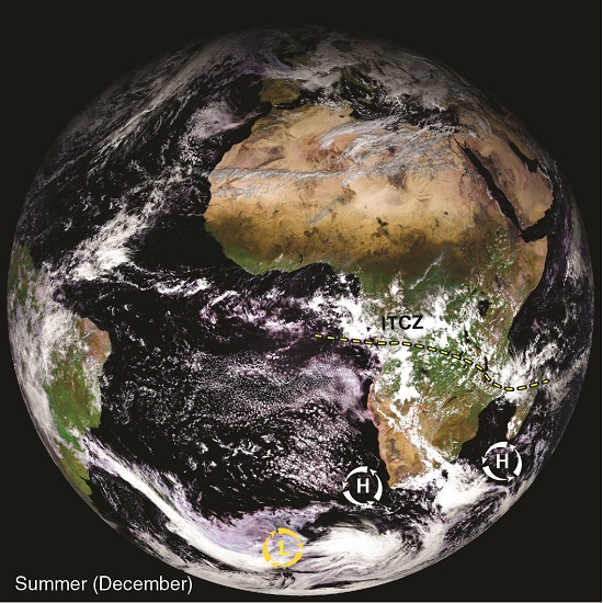
The schematic representation of air circulation illustrates the vertical and horizontal movements of air between the equator and the tropics and how this circulation shifts in relation to Africa between summer and winter. Moist warm air from the Intertropical Convergence Zone spirals upwards causing heavy precipitation over the equatorial region. It is visible as a broad band of cloud in the two satellite images. Now cold and dry, this air is forced out from the equator to the poles where it subsides and forms centres of high pressure. It then moves towards the equator completing the cycle. The two satellite images show the typical patterns of air circulation around southern Africa in winter and summer and the major air pressure and convergence zones.2 The dry high-pressure anticyclones (H) dominate over southern Africa in winter, with low-pressure cold fronts (L) bringing rain to the southwestern areas of the continent. In summer, the Intertropical Convergence Zone (ITCZ) – and other zones – migrate southwards allowing some cloud development over Namibia. Note the drier cloudless regions to the north and south of the ITCZ where the highpressure systems dominate.
Ocean currents and upwelling centres
Earth's oceans have a much greater capacity to absorb and store energy from the sun than the atmosphere above the water surface. The natural flow of the oceans distributes this heat energy – cold dense water moves from the poles towards the equator, while warm lighter water is carried from the equator polewards. By distributing the heat in this way, these ocean currents regulate the temperature of the oceans and the temperature of the air above them, and have a major influence on the weather and climate. This is particularly true when the current that flows along the coast is much colder than the tropical air above it, as is the case with Namibia.

Due to the rotation of the earth, the waters of the world's oceans form currents. The larger and more permanent currents form giant, rotating systems called gyres responsible for regulating temperature, salinity and nutrient movements in earth's oceans. In the southern hemisphere the direction of rotation is anticlockwise while in the northern hemisphere it is clockwise. There are five major gyres in circulation across the globe.
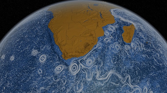
This is an image taken from an animation of the world's ocean currents generated by NASA's Goddard Space Flight centre. It is a synthesis of modelled and empirical data assembled between June 2005 and December 2007. The eddies, known as the Agulhas rings (figure 3.02), are clearly visible where the southerly moving Agulhas current of the Indian Ocean meets the northward moving Benguela Current of the southern Atlantic.
3.02 The Benguela Current system


Namibia's coastal environment is dominated by the cold Benguela Current which forms part of what is known as the South Atlantic gyre.3 The current moves in an anticlockwise direction on its path from south of the African continent towards the equator.
The movement of surface waters results from the dragging effect of the dominant southerly winds (figure 3.04). Although the impetus of the wind would tend to push the waters parallel to the coast, the Coriolis force (resulting from the anticlockwise rotation) deflects these surface waters towards the northwest. The speed of the water in the upper 100 metres decreases with increasing depth and its direction of movement is influenced more and more by the Coriolis effect so that farther down it is deflected at right angles to the wind. This spiralling motion of the surface water and resulting perpendicular water movement at lower depths is known as Ekman transport.
The water that is forced to move away from the shore creates a relative vacuum that causes deeper water to rise and replace it. This is known as 'upwelling' and is the reason why the waters within 100 kilometres of the coast are rich in nutrients and bountiful with life. Upwelling is most pronounced where the continental shelf is narrow.
Seven major upwelling cells or centres occur along the Atlantic coast between southern Angola and the southern Cape.4 The strongest upwelling cells off the Namibian coast are near Lüderitz and Cape Frio. In both areas the winds are powerful, and the inner continental shelf is relatively narrow. The Lüderitz cell is by far the strongest and has the greatest impact on Namibia's marine life since the phytoplankton and zooplankton sustained by the nutrient-rich waters here are subsequently distributed farther northwards by the Benguela Current.
The Benguela Current is active as far north as the waters off Angola where it meets the warm and southerly flowing Angola Current. In addition to this, there is also a southerly flowing countercurrent beneath the Benguela which flows parallel to the Namibian coast, and which is strongest near the edge of the continental shelf.
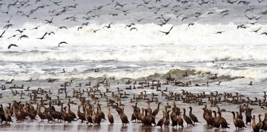
Photo: P van Schalkwyk
The nutrient-rich waters of the Benguela Current fuel a diverse ecoysystem and sustain large populations of seabirds such as these cormorants.
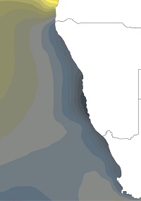
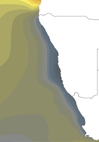
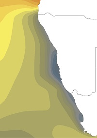
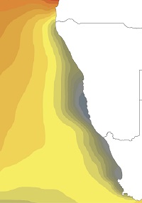
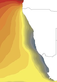
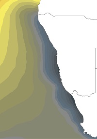
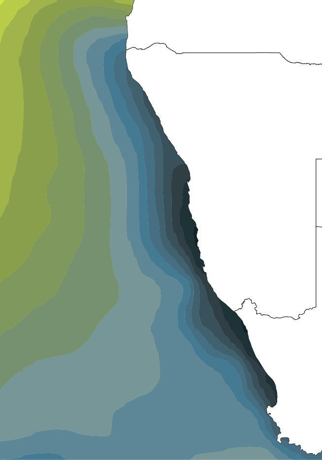
Sea surface temperatures
3.03 Monthly sea surface temperatures, 1982–20115

July

August

September
October
November
December
January

February
March

April

May
June

Although the Benguela is a cold-water system, surface temperatures vary geographically, as well as over the course of the year. The coldest waters are in the south and close to the coast. They are driven north in winter by strong southwesterly winds of the South Atlantic Anticyclone. In summer, warmer waters from the Angola Current push south, but sea surface temperatures remain cold close to the Namibian coast. Warm waters from Angola sometimes persist much longer than usual; such major warm-water events occurred in 1963, 1984 and 1995. Water temperatures off the northern Namibian coast in 1995 were about 8 degrees Celsius higher than usual for that time of year, an event known as a Benguela El Niño.
Sea temperatures have been rising. Over the 25-year period between 1982 and 2007 average sea surface temperature in the coastal and offshore parts of the northern Benguela rose by up to 1 degree Celsius.6

Photo: A Jarvis
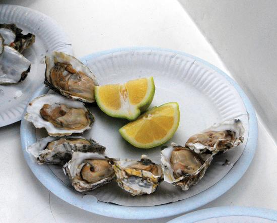
Photo: A Jarvis
Oysters are normally associated with warm ocean waters where they can breed. However there is a small but growing coastal oyster industry in Namibia. The oysters are bred locally onshore and then transferred to ocean baskets that hang from floatation barrels. The greater levels of oxygen and nutrients in the cold Benguela waters mean that the oysters can be harvested much earlier than their European counterparts.