

Ephemeral rivers
Ephemeral rivers often look much the same: dry, sandy watercourses lined by thick bush and trees. But there is a great deal of variation in Namibia's ephemeral rivers. The starkest difference is between the rivers to the west and east of the watershed (figure 4.01). To these two groups can be added a third – the Cuvelai, an ephemeral drainage system sandwiched between the west and east in northern Namibia (figure 4.09).
The rivers to the west of the watershed divide flow westwards – except for the Fish River which flows southwards – and tend to function as we expect of 'typical' rivers. They start as small fast-moving streams with a strong hierarchy of tributaries and clear paths of flow along ruts and channels down steep highland slopes. When they flow, their energy in these upper reaches is significant, eroding the surrounding landscape and carving characteristic boulder-laden riverbeds. As they make their way downstream to gentler gradients, their flows slow and their beds widen before their waters enter the Atlantic Ocean or percolate into the Namib's sands. Compare the Swakop, Kuiseb and Tsauchab Rivers in figure 4.01: the Swakop has a clear mouth into the sea at Swakopmund; the Kuiseb disappears into a sandy delta south of Walvis Bay but occasionally breaks through to the lagoon at Walvis Bay, while the Tsauchab completes its journey in Sossusvlei, some 55 kilometres east of the coast (as the seagull flies). South of Sossusvlei, no ephemeral rivers reach anywhere near the coast.
By contrast, the rivers to the east of the divide flow in an easterly direction and start as larger, slower, sandier rivers. Along their lengths these eastern rivers drop little in elevation, and so have lower energy and limited erosional potential. Many of the smaller rivers and tributaries are often poorly defined and hard to see, and might not flow for decades or even centuries – or may only flow for short distances. All of these rivers wander across thick Arenosol sands until their sluggish flows fizzle away as the water seeps into the porous sand below. While there is little flow above ground, these rivers do recharge groundwater and, in some areas, form pans which become temporary oases.

Photos: H Denker

Namibia's ephemeral rivers have two defining features. Firstly, they are usually dry (indeed, many Namibian children grow up believing that normal rivers are rivers of sand). Secondly, their water flows are extremely variable from one year to the next; long periods without any flow are punctuated by occasional, short-lived flows. The largest floods most frequently occur during February and March, when they recharge dams and groundwater reserves. But they are also unpredictable and potentially hazardous: almost every year people, vehicles and animals are swept away by flash floods. This is the Kuiseb River at Homeb in August 2021 and in March 2018.
4.07 Maximum recorded flow rates in three ephemeral rivers7

Despite being dry most of the time, ephemeral rivers can have very high rates of flow. The maximum flow rate recorded on the Fish River (at Seeheim) was 8,300 cubic metres per second during the exceptional rainy season of 1971/72. This is almost nine times more than the maximum flow ever recorded for the perennial Okavango River over the past 75 years, and illustrates the volatile nature of Namibia's ephemeral rivers. The gently sloping, sandy landscape of the Nossob catchment produces slow rates of flow along the river and has an unremarkable maximum flow rate of 101 cubic metres per second recorded in 1977/78 at Amasib. Any water that reaches the Nossob seeps away into its sandy riverbed during its slow journey southeast. Flows along the Kuiseb normally disappear into its sandy riverbed between Gobabeb and the coast, but occasional floods break through to the sea south of Walvis Bay.
4.08 Total annual runoff and peak floods in three ephemeral rivers8
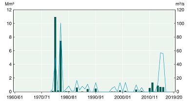
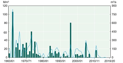

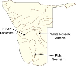

The graphs show the maximum flow rates (lines, in cubic metres per second) and total annual volumes of water (bars, in millions of cubic metres) recorded at gauging stations along three ephemeral rivers – the Fish River at Seeheim, the Kuiseb at Schlesien and the White Nossob at Amasib. This type of information is of particular use when designing a dam or determining intervals between flood events. The eastward-flowing Nossob River and the westward-flowing Kuiseb have more zero-flow years than the southward-flowing Fish River. The Fish has a more constant annual flow provided by its large catchment on rocky and sparsely vegetated Nama Karoo terrain. Consequently, the Fish River and its tributaries supply the country's three largest dams – Neckartal, Hardap and Naute – although they flow through some of Namibia's most sparsely populated areas.