

Colonisation and liberation12
The telling and analysis of history often requires time to pass and wounds to heal. At the time of compiling this atlas, there had been little mapping or spatial analysis of events during the Namibian War of Independence waged from 1966 to 1989 between the People's Liberation Army of Namibia (PLAN) – the military force of the South West Africa People's Organisation (SWAPO) – and the South African Defence Force (SADF), South Africa's armed forces. One study, however, has provided some insight into where military engagements took place during this 24- year war that led to Namibia's independence from colonial rule.
9.05 Military engagements in the Cuvelai basin, 1966–1989

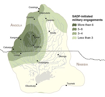
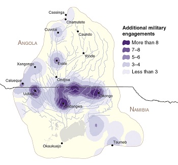
Many of the attacks and battles during the Namibian War of Independence were concentrated in the Cuvelai, especially those fought between 1976 and 1989. These maps illustrate the locations of 383 military engagements in the Cuvelai, which straddles Angola and Namibia. PLAN was on the attack on 209 occasions, while 39 events were attributed to SADF offensives (above). It is not clear which party was on the offensive in the remaining 135 of these military engagements. There is a clear pattern to the spatial distribution of these military engagements. PLAN initiated attacks mainly in Namibia, just south of the Angola–Namibia border, whereas most SADF offensives took place in Angola where PLAN military bases were located during much of this period. The distribution of incidents attributed to either party mirrors this pattern, with more incidences occurring on the Namibian side of the Cuvelai Basin.
9.06 Number of military engagements of the warring parties, 1966–1989

During the first decade of the Namibian War of Independence (1966–1975), relatively few engagements took place in the Cuvelai area. SWAPO's headquarters were in Zambia at that time, but were relocated to Angola following Angola's independence in 1975. Military operations then became more numerous, reaching a peak in 1979 and then declining in the early 1980s. Several factors may have led to the decrease in offensives, including two consecutive years of drought in 1981 and 1982. Thereafter, military activities intensified again, reaching a final climax in 1987.

Photo: J Mendelsohn
The two parties concentrated their offensives at different times of the year. PLAN attacked in the wet season, especially late in the season when water levels in the iishana are often highest, while the SADF conducted most offensives at the end of the dry season. These differences may be related to their respective tactical strategies. PLAN's operations – usually on foot – required concealment, which was best provided by lush groundcover and heavy tree foliage towards the end of the rainy season; rain would have also washed away the soldiers' tracks. By contrast, to move its troops, the SADF depended largely on heavy military vehicles which would have bogged down in flooded areas.
