

Wind
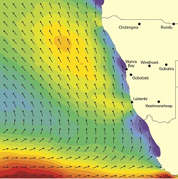
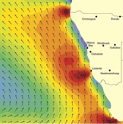
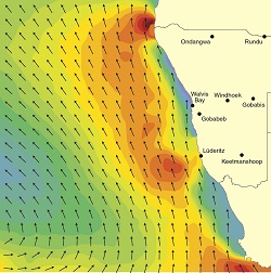
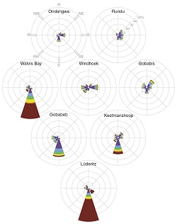
3.04 Wind over Namibia and offshore7
July
October
January

April

July
October
January

April
Average wind speeds and directions for July, October, January and April are shown here for five places in Namibia (wind roses) and offshore (maps). The cold Benguela Current fuels the South Atlantic high-pressure cell located offshore (figure 3.01). This anticyclone acts like a giant turbine blasting air in an anticlockwise rotation towards the coast. This, combined with the Coriolis force (figure 3.02) that deflects the winds northwestwards, produces the wind patterns we see off the Namibian coast. The deflection of winds close to land results in the predominance of southeasterly, southerly and southwesterly winds along the entire coast. Over the land, wind speeds are generally lower and wind directions are more variable, and the proportion of calms (when wind speeds are less than 0.5 metres per second) is higher.
Two zones of strong winds, one around the Kunene River mouth and one at Lüderitz, coincide with upwelling cells caused by the displacement of surface waters and the resulting upward movement of deeper waters to replace them. Wind speeds are highest off the coast during the summer months when temperature gradients are steepest between the cool ocean and the warm land. The coastal stretch from Lüderitz southwards to the Orange River mouth is recognised as being the windiest area in southern Africa and record wind speeds have been measured at Pomona in the Sperrgebiet.8
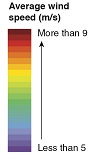
The wind roses below the maps contain several layers of information. They show the direction from which the wind blows (represented by the position of the arm) and how frequently it blows from that direction (represented by the length of each arm). In addition, the colour gradient shows (proportionally) how strong the winds are. In winter the influence of the Botswana Anticyclone results in the prevalence of more easterly airflow in many areas. These East Winds, as they are known, strengthen and become very warm as they descend from the escarpment and blow across the Namib Desert to the coast. The frequency of calms in the table (right) represents the proportion of all records in the set of wind measurements with values less than 0.5 metres per second.
Frequency of calms (%)
| January | April | July | October | |
|---|---|---|---|---|
| Gobabis | 36 | 51 | 49 | 36 |
| Lüderitz | 9 | 14 | 14 | 8 |
| Ondangwa | 55 | 68 | 63 | 53 |
| Rundu | 56 | 59 | 62 | 49 |
| Walvis Bay | 17 | 17 | 18 | 13 |
| Windhoek | 42 | 37 | 28 | 34 |
Shaping our sands9
A

B

C

D

E
F
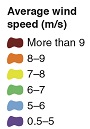
Wind has had – and continues to have – a major impact on shaping Namibia's landscapes by moving great amounts of sand. Much of the sand is transported offshore to the Atlantic, some sand is mixed into more fertile soils that attract farmers, and other sands are moulded into the many forms of dunes that are found in different areas of Namibia. Wind patterns differ greatly, not only across the landscape, but also between the seasons (see the wind roses in figure 3.04). Some of the strongest and most persistent winds are the southerly winds along the west coast that have been instrumental in shaping the Namib Sand Sea. Linear dunes (A), which characterise much of the sand sea and other areas, are commonly considered to be shaped by the counter influence of oblique winds against the dominant air flow. [Image centre 24.19° S, 15.18° E]
Coastal residents are also only too familiar with fiery blasts of air in the winter months. Namibians call them East Winds (or sometimes Berg Winds); the winds are particularly strong and hot. These winds from the east descend over the escarpment, and pick up and carry large quantities of sand over and into the Atlantic Ocean (B). [22.65° S, 13.82° E]
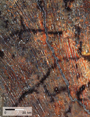
Inland, easterly winds are normally mild, and have evidently been prevalent for many thousands, perhaps millions, of years during which they have moulded landscapes in surprising ways. For example, during long arid periods easterly winds have blown alluvial sands out of drainage courses such as the then-dry Kwando and Okavango rivers and Omatako Omuramba (C) to form the parallel vegetated dunes that we see across large parts of northern Namibia today. [18.96° S, 19.58° E]
More locally, easterly winds have scoured alluvial silts from ancient channels and pans in central-northern Namibia and deposited them just west of the channels where they slowly mix with sand to form the most fertile soils in the area. As a result, people settle and farm crops along the western margins of these old watercourses and pans, where each smallholding is visible as a pale clearing in the surrounding woodland (D). [17.49° S 16.95° E]
The easterly and westerly winds in contest with the southerly winds continue to mould the mobile dunes of the Namib, resulting in the multifaceted star dunes found around Sossusvlei (E) and elsewhere in the eastern Namib Sand Sea. [24.72° S, 15.51° E]
Southern Africa's largest dune field stretches 850 kilometres from north to south and up to 200 kilometres from east to west across much of southeastern Namibia and into Botswana and South Africa. These linear dunes, with a northwest–southeast alignment, were formed during two phases 28,000 and 17,000 years ago by a more intense but similar wind regime to that which occurs there today (F). [23.72° S, 18.81° E]
Image A: Gateway to Astronaut Photography of Earth
Image B: NASA Earth Observatory
Image C: Microsoft Bing
Image D: ESRI ArcGis
Image E: ESRI ArcGis
Image F: Google Earth
3.05 Monthly wind speeds at 08h00 and 14h0010

As with seasonal effects on wind intensity, temperature gradients also influence prevailing wind speeds during the day with stronger winds experienced in the afternoon compared with the morning and evening. At night the land surface cools and so too the air above it; there is consequently less vertical air movement and mixing of air. As the land heats up during the day there is much more vertical air movement and mixing of air layers. At the coast, the rapid heating of the land surface (after the fog has dissipated) during the day results in pressure differences between the warm air over the land (low pressure) and the cool maritime air (high pressure) over the sea. This results in very strong coastal winds with Lüderitz having average wind speeds of over 40 kilometres per hour on summer afternoons. By contrast, wind speeds over the interior of the country are much more moderate.

Photo: J Tait
The strong winds at the coast, particularly in the southern parts attract the attention of wind surfers and kite surfers in search of an adrenalin rush. Winners of the annual Speed Challenge at Lüderitz commonly record speeds in excess of 90 kilometres per hour.