

Namibia's marine world
Typically, the focus on Namibia is on its land surface, with less regard for the part of the Atlantic Ocean adjacent to the country and its waters that lap its shore. This marine world, however, has a major influence on Namibia's climate, hosts important mineral and living resources and is an integral part of the country. Namibia has the right to the resources the ocean offers in its territorial waters and exclusive economic zone.
The Atlantic Ocean stretches westwards from the Namibian shoreline towards South America. The shoreline varies between rugged rocky bays and sandy sea cliffs. The ocean floor descends rapidly beyond the broad continental shelf to depths over five kilometres below the surface. This vast stretch of deep sea is interrupted by the Walvis Ridge, an underwater mountain range or bank, running northeast– southwest out to sea. Between the Walvis Ridge and the continental shelf, mountains or 'seamounts' far greater than anything seen on land rise up from the seabed, their peaks often only a relatively short distance below the waves.
2.02 Ocean floor relief and prominent submarine features off Namibia's coast
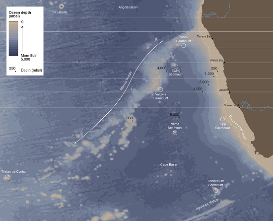

Immediately offshore is the continental shelf – a relatively shallow part of the ocean that forms part of the continent and extends 100–140 kilometres from the coastline in most areas. The widest part near the Orange River mouth extends 180 kilometres offshore, while the narrowest stretch of about 30 kilometres is near the Angolan border. At the edge of the continental shelf, the ocean floor drops steeply into the abyssal plain which reaches depths of more than 5,000 metres below sea level.
The Walvis Ridge is a mountain chain of extinct volcanoes that extends over 2,500 kilometres in a southwesterly direction from the coast at Cape Fria south of the Kunene River mouth to the islands of Tristan da Cunha in the South Atlantic Ocean (about 37.3 degrees south and 12.4 degrees west). The ridge divides the Cape Basin in the south from the Angola Basin in the north, forming a major barrier to the circulation of deep oceanic waters. Some points along the ridge rise over 4,000 metres above the surrounding seabed, and there are several isolated extinct volcanoes that form underwater mountains or seamounts. These elevated areas can be clearly seen in the cross-sectional profiles alongside. For example, the profile off the coast at Walvis Bay passes through the northern slopes of the Ewing Seamount (which at its highest point is about 830 metres below sea level) before intersecting the Walvis Ridge, which forms a relatively flat plateau 200 kilometres wide at approximately 2,400 metres below sea level. While seamounts are usually volcanic mountains rising from the ocean depths, several other landmark features such as banks, slumps and benches are found within the margins of the shelf. Banks are raised areas that can extend over large distances, while slumps and benches result from subsidence, often caused by earthquakes or the explosion of methane hydrates (ice-like solids made up of methane and water) that release large amounts of methane gas from the sea floor.3
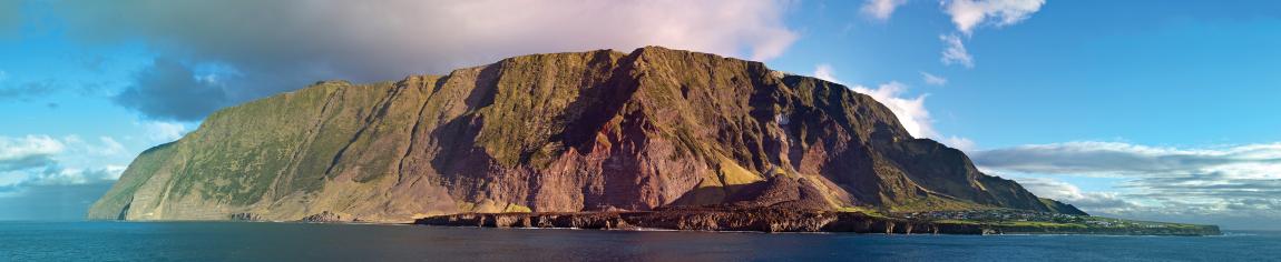
Photo: B Gratwicke
Tristan da Cunha island is an example of a sea mount that rises above the surface of the ocean. It is a part of an archipelago of islands and is an active volcano with its highest point a little over 2,000 metres above sea level. It is home to the most remote island community in the world.
2.03 Namibia's islands4

Namibia's 14 islands all lie close to the coast between Walvis Bay and the Orange River mouth. Most of them are little more than wind- and wave-swept isolated rocks that jut out of the Atlantic Ocean. The largest, Possession Island, covers 140 hectares, but most are less than 10 hectares in size. The islands first attracted interest in the early nineteenth century. Merchants, recognising the value of their vast guano reserves, soon stripped the islands of guano and shipped it to Europe where it was used for manufacturing fertiliser and gunpowder.
Although the heyday of guano mining was between the 1840s to 1860s, it continued well into the twentieth century. On Halifax Island, the removal of the guano in the 1930s was devastating to African penguins that had nested in burrows in the thick guano. In recent years there has been a small recovery with several thousand birds living on the island, however, they were again severely impacted in 2018/19 by an outbreak of bird flu.
The birds and marine life surrounding these islands now enjoy greater protection following the proclamation in 2008 of the Namibian Islands' Marine Protected Area. Formal regulations pertaining to each island were gazetted in December 2012.


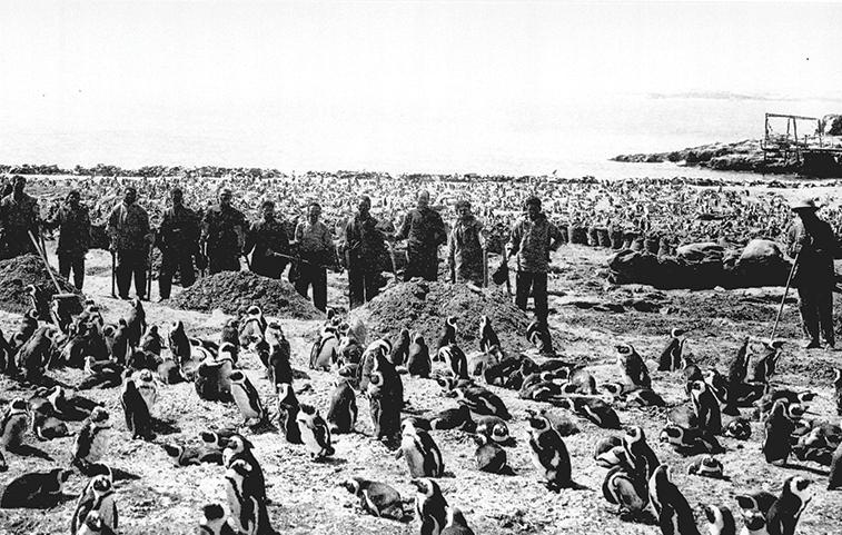
Photo: Swakopmund Scientific Society

Photo: A Jarvis

Photo: R Swart
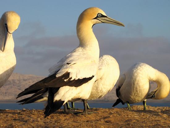
Photo: J Kemper
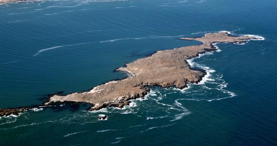
Photo: R Swart
Namibia's islands are vital bases for seals and seabirds. Ichaboe, Mercury and Possession islands are particularly important roosting and breeding grounds for cormorants, penguins and gannets. During 1843–1846, Ichaboe in particular came under intense pressure from the frenzied guano trade at the time. Almost a century later, a team of workers was photographed mining guano on Halifax Island among hundreds of penguins. In the 1950s Namibia's islands were home to significant proportions of global breeding populations of several species such as the African penguin, Cape gannet and African black oystercatcher. Several species found on these islands, such as the bank cormorant, crowned cormorant and Hartlaubs gull, are endemic to South Africa and Namibia, with 80–90 per cent of all bank cormorants breeding on Mercury and Ichaboe islands.
2.04 Coastal margin

The 1,570 kilometres of shoreline from the Orange River mouth to the Kunene River mouth is a mix of rocky outcrops, smooth sandy stretches and intermittent bays and ephemeral river estuaries. The sandy stretches are in constant flux, the sand shifting northwards under the power of the Benguela Current and strong prevailing winds from the south. Of the entire coastline, 61 per cent is predominantly sandy and 39 per cent is mainly rocky.
Over the past few hundred million years, sea level has varied between several hundred metres below and above its present level as a result of uplift, subsidence and climate change. The coastline therefore moved to the west when sea level dropped, or to the east (inland) when it rose.
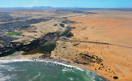
Photo: O Ernst & H Baumeler
The Swakop River and its mouth on the southern edge of Swakopmund. Like all the coastal rivers in Namibia, the Swakop stops wind-blown sand from shifting north. Only the Orange and Kunene rivers have true estuaries with mouths that open to the sea. The mouths of ephemeral rivers are usually closed except at times of exceptional rains and river flow
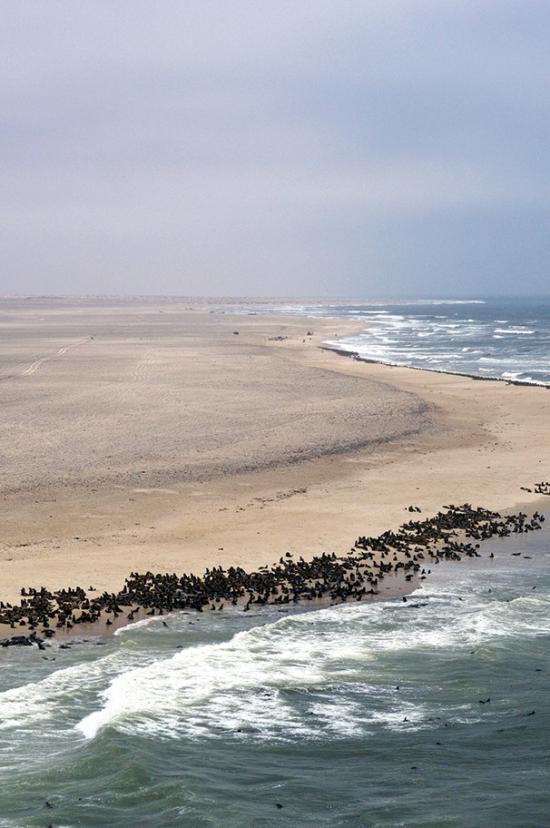
Photo: H Baumeler

Photo: P van Schalkwyk
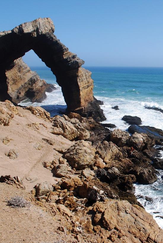
Photo: P van Schalkwyk
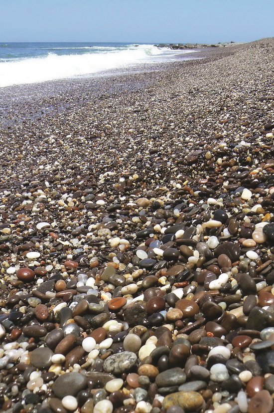
Photo: J Mendelsohn
Namibian shores and beaches come in many shapes and textures. Most are long expanses of sandy beaches, with those in undisturbed areas sometimes taken up by seals. In places, wave action cuts sheer cliffs into the main Namib Sand Sea. Long stretches of the coast are rugged combinations of rocks and dunes, with rock faces that get battered by fierce waves; the iconic Bogenfels arch is an excellent example. Some beaches in the Skeleton Coast are adorned by a great kaleidoscope of rounded, coloured rocks.
2.05 Shifting sands and shipwrecks


Photo: H Dillmann
The Eduard Bohlen was a German cargo ship which ran aground near Conception Bay in 1909 while travelling from Swakopmund to Cape Town. Since then, the wreck has remained the perfect visual marker to monitor the shoreline. In 2004, ninety-five years after it ran aground, the build-up of sand deposits along the coast had added an average of 4.1 metres of beach per year, meaning that the wreck was then about 390 metres inland of the shoreline. In the 16 years up to 2020, the rate of expansion increased to 6.9 metres per year when the distance between the wreck and the shoreline increased by another 110 metres placing it about 500 metres inland, as shown in this satellite image taken on 1 September 2020, and available in Google Earth. [23.99° S, 14.45° E]
2.06 Changing shape of Walvis Bay's peninsula

Walvis Bay's sandy peninsula has changed markedly in recent years. These changes were mapped from images taken between 1973 and 2016 (the image shown here). Over those 43 years, the peninsula extended northwards by about one kilometre, and narrowed to less than half its width, such that only 600 metres of sand separated the ocean on the west from the lagoon on the eastern side of the peninsula. The orange blocks are saltpans prior to harvesting the salt (Image centre 22.98° S 14.47° E).
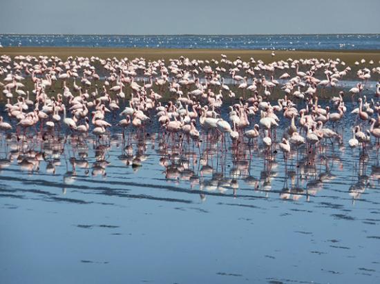
Photo: A Jarvis
The area of Walvis Bay's lagoon has grown substantially, with a net increase in its sediments. The abundance of tiny marine organisms in the shallow sediments provides food to the great numbers of flamingos and other birds that gather here.
What about changes in sea level? Current monitoring indicates that sea level is rising at almost two millimetres per year.5 However, this is largely considered to have been the result of a decrease in air pressure over the Atlantic Ocean and the expansion of its slightly warmer water, rather than from ice melt in polar regions. With the impacts of climate change and additions from glacial melts and ice sheets, this rate of rise in sea level is expected to increase significantly in coming years. Several coastal towns and resort areas will become vulnerable to the destructive forces of the sea and the tides, and a break in Walvis Bay's narrowing peninsula may come sooner than is expected.