

Prominent features
Most of Namibia's conspicuous features can be divided into two groups: those formed by depositional processes driven by water and wind, and those formed from igneous rock. Most aquatic features are shallow, such as pans and floodplains, although some deeply incised valleys have also been worn into the Namibian landscape. Sediments eroded from rocks by wind and water contribute to the wind-blown or 'aeolian' deposits (figure 2.12) that cover more than a third of the country. Intrusions of igneous rock, which cooled slowly as they emerged from the earth's molten mantle tens of millions of years ago, have stood the test of time, remaining as prominent features on the Namibian landscape.
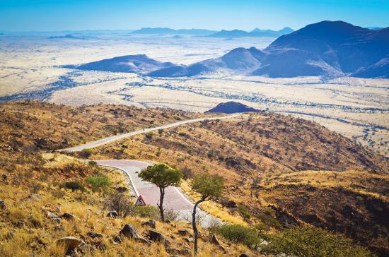
Photo: JB Dodane
The escarpment runs northwest–southeast parallel to, and east of, the coastline. This view is from the top of the Spreetshoogte Pass, one of eight impressive passes that traverse the escarpment to connect the coastal plain and the interior of Namibia. Large sections of the Namibian escarpment were created from deep sea sediments being squeezed, heated and moulded into metamorphic rocks during the formation of Gondwana some 900–550 million years ago. Ever since, the escarpment highlands have been eroded down from higher elevations to their current levels.
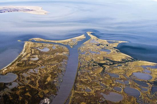
Photo: P Lambrecht
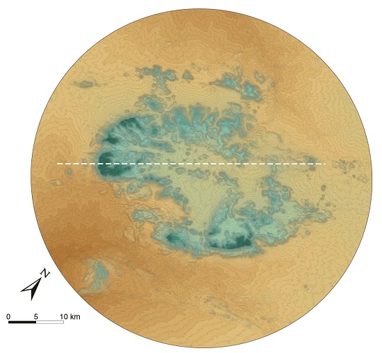
Etosha Pan covers some 4,960 square kilometres. It is the lowest remaining part of a much bigger palaeolake that once stretched further north into Angola. At that time, the Kunene River flowed into the lake and rainfall was periodically higher than it is presently. The palaeolake shrank when the the Kunene changed course to follow its current path to the coast. Nowadays, Etosha is occasionally inundated by heavy local rainwater and by southward flows through the Cuvelai and then along the Ekuma River to its delta in Etosha, shown here in the foreground of this image. Once the water in the pan evaporates, winds scoop particles of clay from the pan's surface and deposit many of them as fine sediments to the west of Etosha. The continued scouring action of wind continues to lower Etosha's surface into a deflation basin.
2.12 Namibia's dune fields8

Over one third of Namibia (35.4 per cent) is covered in wind-deposited sands, Arenosols. Most of these sands are now covered by vegetation, especially in eastern Namibia, and demarcated as 'wind-blown sands' on the map. Elsewhere, there are large areas where the action of wind is clear. The most noticeable examples are along roads, such as those between Walvis Bay and Swakopmund or between Lüderitz and Aus, where sandstorms sometimes obscure the road. The Namib Sand Sea was formed by such winds, which carried sand from the Atlantic Ocean and blew it onto the land. That sand had previously been carried by the Orange River. There are other active dune fields in the Namib, south of the Kunene River, as well as in southeastern Namibia where dunes stretch over hundreds of kilometres.9 Dune fields that formed in earlier arid periods are visible in Bwabwata National Park (Zambezi Region), and in parts of Kavango East, Kavango West and Otjozondjupa.
2.13 Shifting dunes
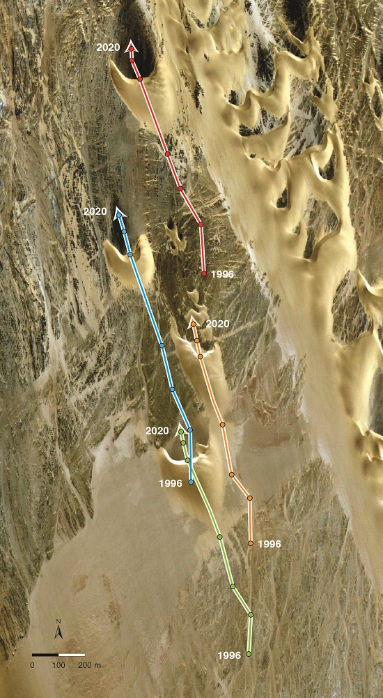
Barchan sand dunes are produced by strong winds that blow predominantly from one direction. The horns of the dunes point away from the prevailing wind, which along most of the Namibian coast is southwesterly to southeasterly due to the strong anticyclonic circulation (figure 3.04). This image shows the movement of a few barchan dunes on the edge of a dune field in the northern Namib. The points marked show the position of the central ridge of each dune in 1996, 2000, 2003, 2008, 2016, 2018 and 2020. Over the 24-year period, the dunes moved between 900 and 1,000 metres in a northwesterly direction, at an average rate of 38–42 metres per year. The image was taken in 2016.10 [18.01° S, 11.88° E]
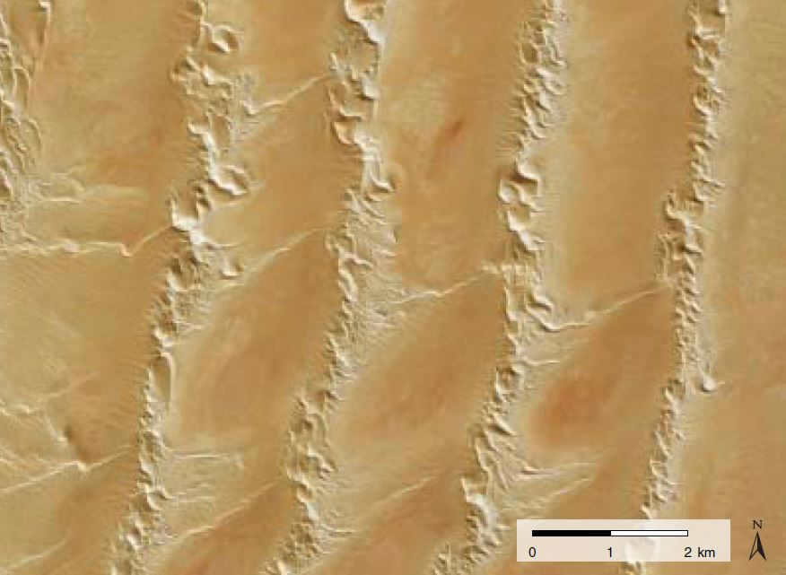
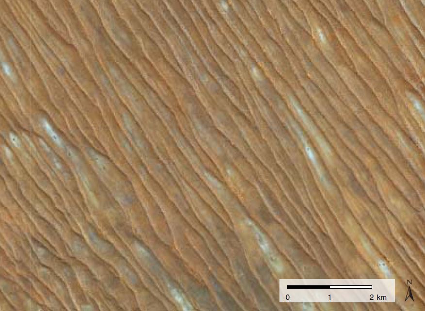
These satellite images illustrate the characteristics of longitudinal dunes in Otjozondjupa northeast of Grootfontein, the Namib Desert (middle), and in the Kalahari in southeastern Namibia. These dunes all form parallel to the dominant wind direction, which in turn follows the pattern set by the high-pressure system that dominates the subcontinent during the winter months). Few plants grow on dunes in the Namib, while many camel-thorn and other trees dot the dunes in the southeastern Kalahari. Dense bush and trees cover the ancient, fossilised dunes in the northeast. Their interdune valleys are more fertile than the sandy dunes and are therefore often cleared for crops. The Namib's longitudinal dunes and the northeast's fossil dunes are spaced at intervals of 2–3 kilometres, whereas most dunes in the southeast are 300–500 metres apart. Each image shows an area of 75 square kilometres (10 x 7.5 kilometres). [18.99° S, 19.04° E; 24.21° S, 15.01° E; 25.79° S, 19.58° E]
2.14 Namibia's mountains, craters and canyons

Namibia's prominent peaks and cavities were formed in a variety of ways. Those most easily identified are inselbergs, such as Spitzkoppe illustrated below. Many of these iconic features were formed in unusual ways and are thus interesting not only for their prominence but also for the events that led to their making. This map shows the locations of these features.

Photo: T Figueira
The majority of Namibia's monumental landforms are of igneous rock, such as the Brandberg, and Erongo and Paresis mountains, and Spitzkoppe seen here. These rocks intruded through weaknesses in the earth's crust that resulted from the break-up of Gondwana about 132 million years ago.
Omatako Mountains


The Omatakos are Namibia's iconic twin-peaks just west of the main road between Okahandja and Otjiwarongo. One is capped with hard dolerite and the other with basalt; these caps protect the softer underlying layers of sandstone. Omatako is an Otjiherero word, meaning 'buttocks'. In this image of them they are modestly hidden under a cover of clouds as a result of moist air rising, cooling and condensing. Respectively, the two mountains rise about 600 and 800 metres above their surroundings.
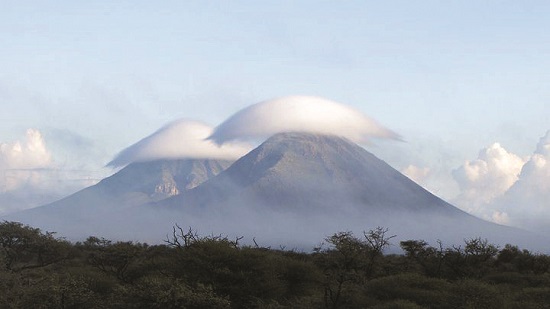
Photo: Elickbeu (https://www.flickr.com)
Brukkaros
Despite looking like an extinct volcano with its clear rim and what appears to be a caldera, Brukkaros is not a volcano. The formation started as an intrusion of igneous magma about 80 million years ago, which forced the surrounding ground upwards and created a fissure that eroded and eventually formed a lake. The magma heated the water and, with the expansion, caused a massive explosion that hollowed out the mountain into its present form.11 Its ridge rises about 500 metres above the surrounding lowlands.

Photo: T Robertson
Gamsberg


Gamsberg's flat top is 2,332 metres above sea level, and is the highest point on the escarpment, commanding a grand view over the Namib to the west. It is covered by a hard quartzite layer that protects the mountain from erosion. Beneath its capping, Gamsberg is granite formed from magmatic intrusions some 1,100 million years ago.

Photo: A Jarvis
Moltkeblick


At 2,479 metres above sea level, Moltkeblick is the second highest peak in Namibia; just 94 metres lower than the highest of them all, Brandberg. Moltkeblick is the highest point of the Auas Mountains, which are part of the Khomas Hochland landscape. These highlands are metamorphic rocks formed during the Damara Orogeny, a mountain-building period when deep marine sediments were forced upwards during the formation of Gondwana some 550 million years ago. Under tremendous heat and pressure, the sediments were tilted, warped, and metamorphosed into the mica schists that are common around Windhoek today.
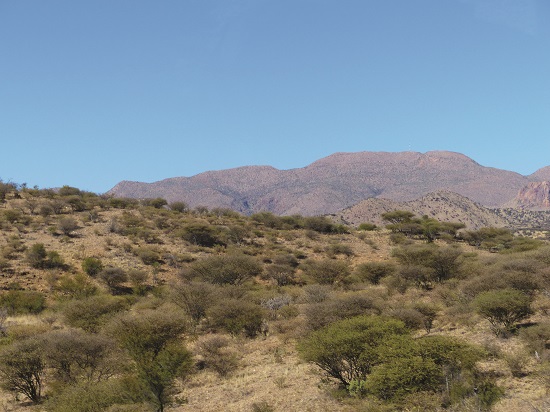
Photo: K Potto (https:// commons. wikimedia.org/ wiki)
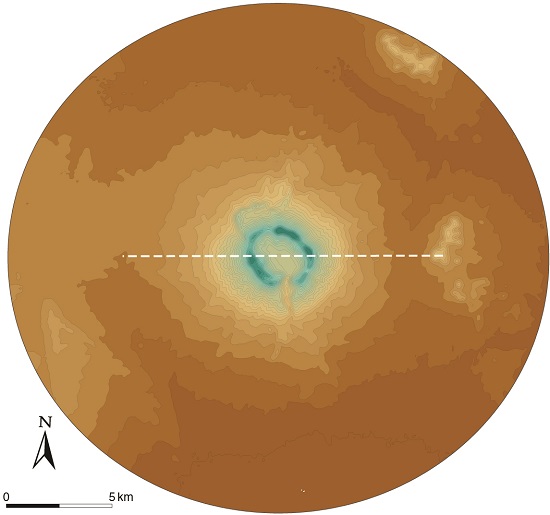
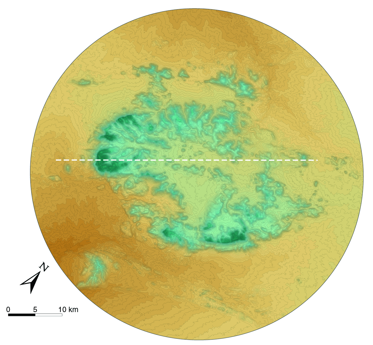
Messum Crater


Messum Crater is the remnant caldera of a massive volcano. It lies halfway between the coast and Brandberg and has a diameter of about 18 kilometres. This volcano is thought to have produced some of the Etendeka basalt lava flows that cover large areas of Namibia and Angola, and Brazil where it is called the Paraná Formation. The entire volume of Paraná–Etendeka basalts produced during this extraordinary eruption is estimated to be over 800,000 cubic kilometres in volume – an amount that could cover an area slightly smaller than Namibia in a kilometre-thick layer of basalt.12
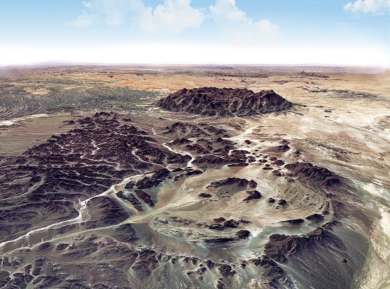
Photo: Google Earth and Bing images via Terraincognita, draped over Shuttle Radar Topography Mission data
Brandberg and the Erongo Mountains


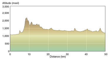
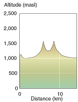
Brandberg is Namibia's highest point and tallest mountain, rising as high as 2,573 metres above sea level and about 1,000 metres above its immediate surrounds. Both the Brandberg and the Erongo Mountains formed from igneous intrusions around 132 million years ago during the break-up of Gondwana. Masses of magma pushed up through the crust, but never reached the earth's surface, and then slowly cooled into the granite of these and many other inselbergs in central Namibia. Erosion of hundreds of metres of the coastal plain led to the exposure of these once subterranean mountains. Both mountains are roughly circular, Brandberg having a circumference of about 85 kilometres, slightly smaller than the more dissected and lower Erongos at about 100 kilometres.
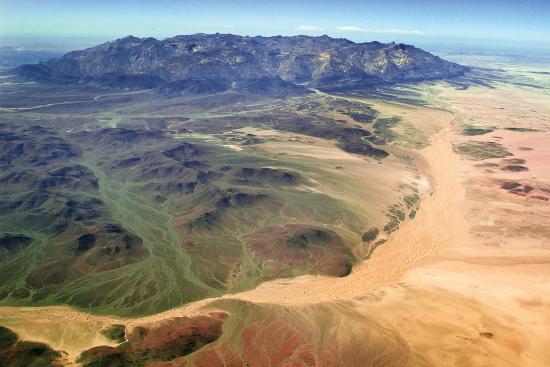
Photo: T Figueira

Photo: C du Plessis
Fish River Canyon


Fish River Canyon is the second largest canyon in the world. Its origins date back to over 500 million years ago when plate movements led to the formation of a broad valley or 'graben' running north to south. The river that developed in the valley cut down through rocks of the Namaqua Metamorphic Complex, which date to 1,200–1,000 million years ago. At times, the Fish was a free-flowing river; at others, it was a glacier. The depth and erosion of the canyon is a product of several factors: the volume of water provided by its catchment; the hardness or erodibility of the underlying rock; and the river's energy in being pulled by gravity to its 'base level' on the coast. The further a river drops, the greater its energy; that energy also increased when the canyon and the margins of southern Africa seemingly rose after breaking apart from present-day South America during the breakup of Gondwana.

Photo: O Ernst
Waterberg Plateau


Waterberg is capped with rocks of the Etjo Sandstone Formation, which also covers Mount Etjo to the northeast of Omaruru. The sandstone formed from wind-blown sands that settled in rift valleys that developed along a southwest–northeast axis about 240–230 million years ago. Waterberg and Mount Etjo gained prominence when much of the surrounding area was later eroded away.13

Photo: C Begley
» View/download locations map (jpg)
» View/download Brandberg map (jpg)
» View/download Brandberg profile (jpg)
» View/download Brukkaros map (jpg)
» View/download Brukkaros profile (jpg)
» View/download Erongo map (jpg)
» View/download Erongo profile (jpg)
» View/download Fish map (jpg)
» View/download Fish profile (jpg)
» View/download Gamsberg map (jpg)
» View/download Gamsberg profile (jpg)
» View/download Messum Crater map (jpg)
» View/download Messum Crater profile (jpg)
» View/download Moltkeblick map (jpg)
» View/download Moltkeblick profile (jpg)
» View/download Omatakos map (jpg)
» View/download Omatakos profile (jpg)
» View/download Waterberg Plateau map (jpg)
2.15 Dykes14

Thousands of linear dykes line Namibia's surface, and many more are hidden beneath the ground. Those formed during Gondwana's break-up (132 million years ago) are called Etendeka dykes. They formed when the earth’s crust weakened during the break-up. Intrusions of magma then forced their way into weakened cracks and solidified into vertical wall-like dykes, or between layers of rocks where they hardened into horizontal plate-like sills. Other dykes formed at earlier times during different periods of tectonic fracturing. Those of the Karoo period formed 300–180 million years ago. Older dykes were probably related to processes 2,650–1,200 million years ago.

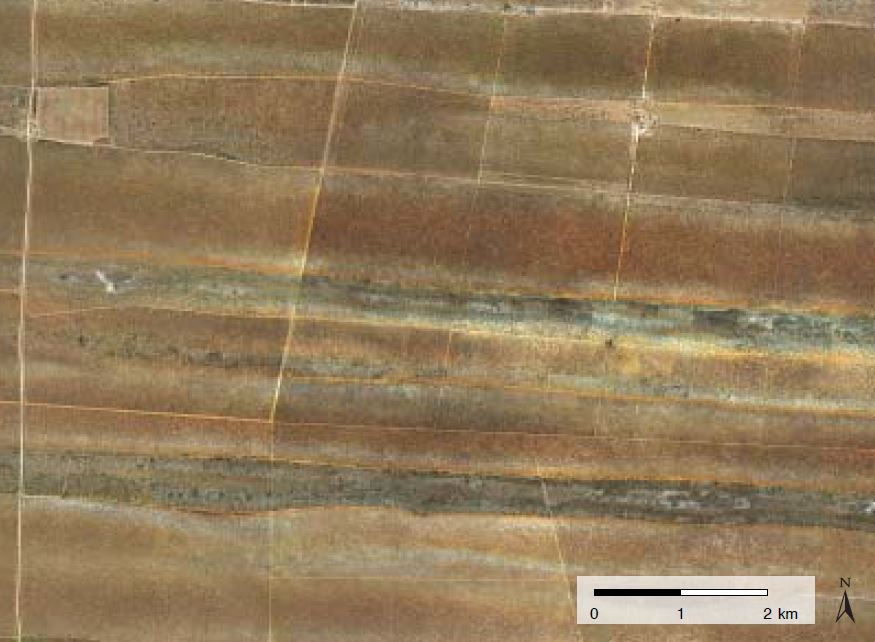
The dark lines in this satellite image are Karoo dykes 50 kilometres northeast of Henties Bay. [21.66° S, 14.44° E]