

Groundwater, a vital hidden resource
Groundwater is a critical water resource for Namibia, and during periods of low rainfall it becomes all the more important. Much of it is now pumped from deep aquifers, but water from springs and hand-dug wells has been a vital source of water in Namibia's interior for aeons. But groundwater has become particularly valuable over the past 130 years as Namibians established themselves in permanent homes and villages across the country, often far from any other water source.
Not all groundwater resources are equal though – there is a great deal of variation in their availability and quality. Some are plentiful and fresh, while others are brackish, dry up intermittently or are difficult to reach. Hidden from view, groundwater remains somewhat intangible and poorly understood by many of us. Our understanding of how much there is in an area, how deep it is, where and how it is recharged and how to safely and sustainably abstract it requires a good knowledge of geology and aquifers, and long-term monitoring.

Photo: J Mendelsohn

Photo: Google image
Artesian springs bring groundwater to the surface. Some, such as the one here at Gobaub in Etosha National Park, have probably supplied water for tens of thousands of years to wildlife and people living in a vast surrounding area. Attracted by the water, concentrated activity has led to the clearing of vegetation around the Gobaub spring, for example by elephants that trample plants and often push over trees. This makes Gobaub visible from hundreds of kilometres above Earth. The actual spring is the tiny black point in the centre of the pale bare area, which has a diameter of about 500 metres. [19.31° S, 16.42° E]
Types of aquifers and their productivity
Below a certain depth, the water table, all pores and other open spaces are normally filled with water in zones called aquifers of which there are two main types. Porous aquifers hold their water in tiny spaces or pores between grains of sand, gravel, sandstone or conglomerates, while fractured aquifers hold water in gaps where hard rocks are jointed, dissolved or broken (figure 4.12). Certain types of rock dissolve in contact with this groundwater widening the gaps and forming underground caves, some of which hold subterranean lakes. The rich aquifers in the karstveld are formed in such rocks. Sometimes, one aquifer, separated by an aquiclude, overlays another; examples are the Ohangwena aquifer that straddles the border between Ohangwena and Angola, and the Auob and Nossob aquifers in the Stampriet–Aranos area. The characteristics of these vertically separated aquifers and the water they contain can differ substantially.
Groundwater, like surface water, generally follows gravity by flowing from higher to lower levels. Along the way, salts dissolved from the surrounding rock or soil are picked up. The underground movement of water is, however, typically very slow. For example, groundwater takes an estimated 15,000 years to travel a distance of 15 kilometres from the Auas Mountains just south of Windhoek to the hot spring near the Alte Feste in central Windhoek. Water in this spring has a temperature of 80 degrees Celsius, not far below boiling point, which suggests that it has probably been circulating 2–3 kilometres below the surface. Rainwater that falls in one area may therefore recharge aquifers further down the catchment, and possibly far away, even across international borders. The management of aquifers then becomes the responsibility of more than one country.

The rich karst aquifers found around Tsumeb–Otavi–Grootfontein are in carbonate-rich rocks, such as dolomite and limestone. These rocks are dissolved by groundwater along existing joints and fractures, creating large openings and underground lakes over time such as those shown in this diagrammatic cross-section. This karst rock formation encircles southern and western Etosha and stretches up to Namibia's north-western border. Several springs on the edge of Etosha Pan are fed by water that seeps along joints of the Karstveld.

Photo: JB Dodane
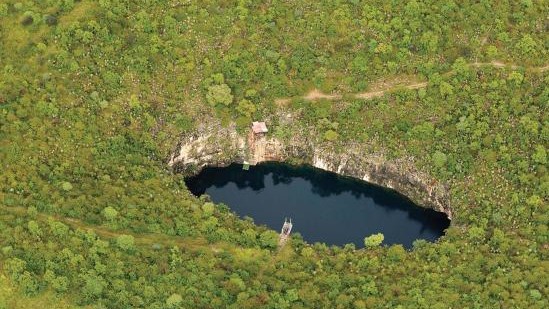
Photo: H Denker
Seldom can we see water in an aquifer. Two exceptions are at Lake Otjikoto (first photo) and Lake Guinas (second photo) where the natural dolomite and karst rock roofs have collapsed to reveal underground lakes of water. To help understand this groundwater resource, water levels at Otjikoto have been monitored over the past 50 years (figure 4.14).
4.12 Major aquifer types, supply potential and direction of groundwater flow12
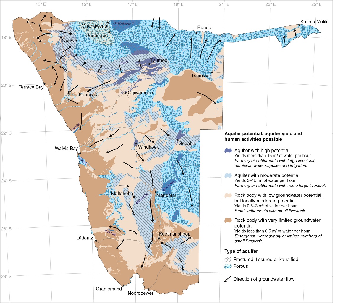
This map provides a view into a different aquatic world, one that is invisible underground. Water is stored in porous and fractured aquifers; some hold very modest amounts of water, while others have an abundance that is hard to imagine in such an arid environment. Among Namibia's richest aquifers are the karst, Koichab, Kuiseb, Maltahöhe, Ohangwena II, Omdel, Stampriet and Windhoek aquifers.
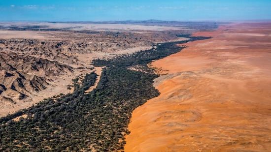
Photo: L Pollik
Significant volumes of water lie beneath the riverbeds of certain ephemeral rivers. This is true of the Kuiseb River which supplies Walvis Bay and Swakopmund with water pumped from its shallow aquifer at Rooibank. The Kuiseb also stops the northward march of Namib dunes (right) onto the gravel plains (left).
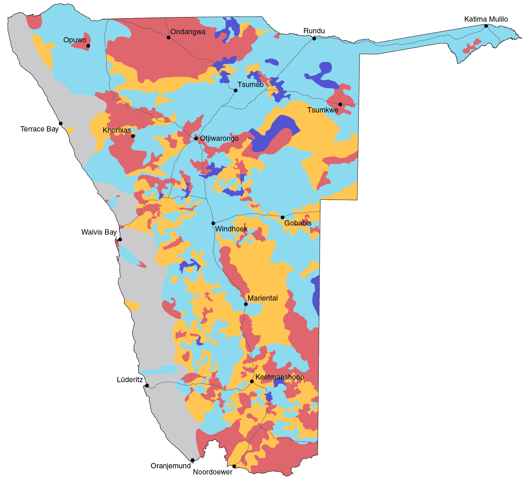
4.13 Borehole yields and their distribution13

Over the years, huge numbers of boreholes have been drilled in the search for water; the yields measured at the time of drilling are shown here. There is a high degree of local variation in the productivity of boreholes, especially in fractured aquifers. One borehole can tap into a small, rich aquifer, while others nearby yield little water. Nonetheless, even a relatively low yield of 1 cubic metre of water per hour may be adequate to supply a small village. Boreholes with yields of 15 cubic metres per hour or more can supply enough water to irrigate large fields or supply bulk water to towns, assuming that the aquifers tapped are regularly recharged.
The distribution of boreholes across Namibia is also reflected in this map. Most boreholes have been drilled on private farms. The comparative scarcity of boreholes elsewhere is due to several factors: the depth or salinity of the groundwater; high installation and operation costs; the presence of better sources of water; and, in some cases, the low priority given in the past to water supply in sparsely populated communal areas. The small number of boreholes in the Cuvelai, for example, is due to the salty deeper groundwater in that area, which is unsuitable for most uses, and which led to the development of supplies of clean, piped water from the Kunene River (figure 4.21).
4.14 Monitoring groundwater levels14


Groundwater levels are regularly measured at selected monitoring boreholes around the country to determine water volumes and rates of recharge of these hidden resources. The graphs here show examples of how groundwater levels fluctuate from month to month, year to year and over much longer periods. Whilst the level of water below the ground at Leonardville remains fairly constant, elsewhere it changes quite dramatically. A drop in water level to greater depths below the surface may indicate that the rate of abstraction is higher than the rate of recharge. Depending on the characteristics of the aquifer, it may respond quickly even to small rainfalls, whilst the level of water in another aquifer might only show a change in water level after a number of good rainy seasons, such as those between 2000 and 2011.
Recharge of the aquifer under the delta of the Omaruru River (Omdel) has been enhanced by the building of an embankment wall across the river, which traps the water so that it can sink into the sand and aquifer below. Yields increased from 2.8 to 4.6 million cubic metres per year after this dam was built15, but the aquifer is only recharged when substantial flows come down the Omaruru River, as happened in 1997, 2001 and 2009. A more sophisticated way of recharging the Windhoek aquifer has recently been introduced, which involves pumping treated water piped from Von Bach Dam into the aquifer.

Photo: M Orti

Photo: H Denker
The reliability and long-term sustainability of boreholes depends on them being recharged at rates equal to or greater than the rates of abstraction. Land degradation reduces aquifer potential in different ways. For example, the loss of plants and erosion of topsoil accelerates runoff and increases soil compaction, thereby reducing infiltration and groundwater recharge (top). Invasive bush (middle) and alien plants often use greater amounts of soil moisture and groundwater than natural vegetation, thus reducing the availablilty of water for other uses.

Photo: J Mendelsohn
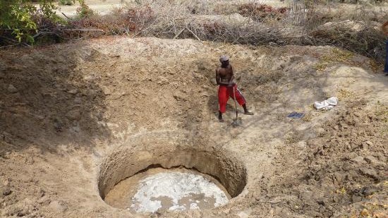
Photo: J Mendelsohn
In central-northern Namibia, two types of hand-dug wells have long been used to access shallow groundwater. Water is winched up in buckets in eendungu wells that can be as deep as 20 metres and are only dug in soils that are stable and firm (left). Shallower omifima wells are seldom deeper than 3–4 metres and typically cone-shaped because they are dug in loose sand (right). These omifima are often in clusters, many of which are clearly visible in Bing or Google Earth images.
4.15 Groundwater quality16
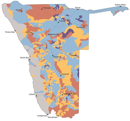
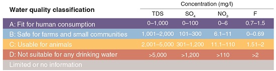
The chemical quality of groundwater varies greatly across the country and is largely determined by the type of rocks through which it has passed. However, the quality of water may also be changed by recharge, abstraction or pollution. In this map groundwater quality is disaggregated into four classes of drinking water. Class A indicates that the water has low concentrations of ions and total dissolved solids, and is fit for human consumption; this is the case in just small pockets of the country. Class B is regarded as safe for farm use and for small groups of people. Class C can be used to water animals, but requires treatment or dilution for long-term human consumption; while Class D is not suitable for drinking.17 Water quality data are not available for the remaining 12.3 per cent of Namibia. The most frequently measured chemical parameters of water quality, which are assessed using the Namibian Water Quality Standards values (in milligrams per litre) shown in the table, are total dissolved solids (TDS), sulphates (SO4), nitrates (NO3) and fluoride (F).
It is important to note that this map illustrates the general pattern of water quality. In almost all areas there are exceptions (figure 4.16). For example, some boreholes might deliver Class D water in an area where Class A water is the norm. The converse is true where Class D water predominates, but some boreholes deliver groundwater fit for consumption.
4.16 Boreholes and groundwater quality18

Class A: Fit for human consumption

Class B: Safe for smaller communities
Class D: Total dissolved solids

Class D: Sulphates

Class D: Nitrates

Class D: Fluoride
While boreholes delivering water fit for consumption (Class A or Class B) are widespread, there is also a high degree of local variation in quality – often from one borehole to the next. One or two chemical properties are often responsible for making the water of certain boreholes unsuitable for human consumption. These four maps each show the distribution of boreholes found to have high, Class D levels of one of four chemical properties that are routinely measured: total dissolved solids (TDS), sulphates (SO4), nitrates (NO3) or fluoride (F).
Total dissolved solids is a measure of the combined concentration of dissolved substances, especially inorganic salts containing calcium, magnesium, potassium, sodium, carbonates and chlorides. High concentrations of sulphates in drinking water can cause diarrhoea and dehydration. Water with a high nitrate concentration may impair the transport of oxygen in the blood, especially in small babies. Excess amounts of fluoride can lead to fluorosis, which can cause mild conditions, such as stained and pitted teeth, or even severe crippling skeletal conditions.
» View/download map - Class A: Fit for human consumption (jpg)
» View/download map - Class B: Safe for smaller communities (jpg)
» View/download map - Class D: Total dissolved solids (jpg)
» View/download map - Class D: Sulphates(jpg)
» View/download map - Class D: Nitrates (jpg)